Tuesday, January 31, 2023

Calm, Cool, and Collected

 TL;DR: 

Its cold and clear today with now snow in the next few days, but there might be something coming early next week. 

Nowcast:

It is very cold but sunny today. Alta is reporting around 2 F at the base. Its mostly sunny so the sun should help with keeping you warm, but don't count on it. Winds are light at around 2-5 mph so wind chill wont have a super strong effect. 


Short term:

It will remain clear and cold for the remainder of the week. An area of high pressure is moving over us until the end of week. There wont be an new snow this week so prepare to ski some hard pack and some possible ice on the groomers. The cold temps should keep some powder around is areas that dont get as much sun, but you will have to look for it.

High pressure moving in from the west

Little moisture in the upper atmosphere, maybe a few clouds on Wednesday

Long term:
This week will be a bust for snow, but early next week is looking promising. Late Sunday and into Monday Should provide us with the right amount of moisture and vorticity to give us more snow. Its hard to say at this point how much snow the mountains will get, but it should be a good amount.


Monday, January 30, 2023

High Pressure Hypnosis

TL;DR:

High Pressure ridge hanging over the area for today bringing cold temps and some sunshine today.


Nowcast:


Good morning and I hope everyone is staying warm! Even with the sun poking out today expect temperatures up in the mountains to be around 10-15°F with light southwesterly winds. Wind chill will keep the temperatures feeling low so make sure to pack some extra layers and sunscreen.

Hidden Peak webcam showing some stunning views this morning! Snowbird


Short term:


As the last storm rolls out of our area, this high pressure system will be pushing its way into Utah. Expect more clear skies and cold temps through the next 36 hours. Sunny days will make your right turns look better!

High pressure making it's way, as the storm moves out U of U Wx


Long term:


It's looking a bit dry throughout the week with little to no chance of precipitation, get out and enjoy the sun while it's out. Another Low pressure system is developing off the coast and should be rolling into Utah through the weekend into early next week. This next cycle is too far out for the models to agree on what it will exactly bring in, as always stay positive and keep the stoke up for this amazing winter we've had so far.


Backcountry comments:


If you will be traveling in the backcountry make sure you have the proper equipment and know before you go. For all things avalanche head over to our friends at the Utah Avalanche Center.


Saturday, January 28, 2023

Snow Now, Sun Later

TL:DR: This weekend's storm will persist through early Monday morning then a ridge will move into the region and remain for the majority of next week. 

Nowcast: It is currently 22 F at Brighton and 18 F at the base of Alta with moderate-heavy snowfall rates and calm winds. Plan on low-light goggles for the entirety of this weekend. 

(Alta, Mt Superior https://www.alta.com/weather)
        

Past 24-hour snowfall totals: 

Alta: 12" 

Brighton: 17" 

Deer Valley: 9" 

Park City: 10"

Snowbird: 11" 

Solitude: 12" 

Short-term forecast: Snow will continue from this storm until early Monday morning. High temperatures today and Sunday will peak in the upper teens with winds sustaining 10-15 mph mid-mountain with gusts exceeding 25 mph at 9000' ridgelines. 

(SREF snow and precip totals, Univ Utah:https://weather.utah.edu/)

Snowfall Forecast Through Sunday:

Alta/Snowbird: 8-16"

Brighton/Solitude: 6-14" 

Deer Valley/PC: 5-8"

Long-Term Forecast: High pressure will build its way into the region early Monday bringing clear skies and high radiational cooling at night. This ridge doesn't look to be too stubborn and will be pushed out of the region around Friday next week by a shortwave or two. Models aren't in complete agreement with the timing of the first shortwave moving into the region but it looks to be a progressive pattern of multiple shortwaves. We will have to wait and see. 

(500 mb geopotential height anomaly, GFS Tropical Tidbits: https://www.tropicaltidbits.com/analysis/models/)


Friday, January 27, 2023

Snowy Weekend

TL;DR:

    A snowy weekend is on tap for the Wasatch, with two weak to moderate systems impacting the range.

Nowcast: 

    Park City Mountain Resort is the only area in the central Wasatch that is reporting new snow this morning, with 1 in. in the past 24 hours. Under low level southerly flow and upper level west-northwest flow, snow is entering the region particularly north of I-80. Radar estimated precipitation rates from the KMTX radar at 1449 UTC reflect this well, with the highest precipitation rates in the northern Wasatch.

Source: University of Utah Department of Atmospheric Science

Short-term Forecast: 

    An upper-level trough passes through the region tomorrow morning, bringing moderate precipitation, especially areas to our north. The 0600 UTC GFS forecast shown below predicts the trough axis to be centered over Utah at 8:00 a.m. local time tomorrow (upper left panel) bringing maximum 3-h precipitation totals of 0.05 to 0.1 in (upper right panel). Nothing too impressive, but this will provide a nice little refresh.
Source: University of Utah Department of Atmospheric Science

Under west-northwesterly crest-level flow (lower left panel), snow-to-liquid ratios should be on the higher side, so this will be a nice fluffy event. The typical NW flow favored areas of LCC should perform best in the central Wasatch during this event.

Through 5:00 p.m. local time, the GFS calls for just 0.24 in. of total precipitation at Alta, while the HRRR forecasts 1.03 in. of liquid water equivalent for the site. If we meet in the middle of the two forecasts, this would translate to roughly 7-10" of snow. Not a huge storm, but a nice refresh to start the weekend.

Mid-Long Range Forecast:
   
    We dry out briefly on Saturday afternoon and evening, but that won't last long, as another wave of precipitation will bring snow to the central Wasatch on Sunday around midday. 

We will be on the periphery of a closed low (upper left panel) that will bring heavier precipitation to the Sierra Nevada, while the Wasatch will see more modest precipitation rates, before things dry out by Monday morning.
Source: University of Utah Department of Atmospheric Science

Expect another 5" inches from this second wave. Again, not huge, but it'll be a nice refresh. The two precipitation systems show up nicely on the University of Utah Alta GFS derived forecast. We can clearly see the action getting going today, a brief break on Saturday, and then another impulse on Sunday. The GFS is drier than the HRRR, and I expect totals to be a bit higher than what the GFS calls for in the plot shown below.

Source: University of Utah Department of Atmospheric Science

We'll clear out and warm up to start the work week.

Snowfall Forecast:

For the entire weekend, here are my forecast snowfall totals.

LCC: 10-15" (will do well under NW flow)
BCC: 8-12"
PC/DV: 6-10"

Enjoy the new snow!

Thursday, January 26, 2023

Anticipation Builds

 TL;DR:

Dry weather continues in the short term while the likelihood of a significant storm this weekend is increasing.


Nowcast

It's cold out there! Temperatures range from 10-18F at lower and mid-elevations. On the highest peaks, Mt. Baldy is running right around 9F with a wind chill of -13F. That's pretty cold! Light to moderate winds can be expected with sustained winds around 30mph and gusts to 40mph on the highest ridgelines. The webcam image below from the top of Hidden Peak at Snowbird shows windy conditions with sunny skies above the stratus clouds capping the inversion in the Salt Lake Valley below. 

Image courtesy of Snowbird.


Short-Term Forecast

A longwave ridge of high pressure will continue to park itself, centered just off the coast of California. The loop below shows lower-level water vapor satellite imagery, with blue/white/green colors representing regions with more moisture and yellow/orange colors representing drier regions. Note the broad anticyclonic (clockwise) rotation of the ridge. Because this ridge is centered further to our west, it has allowed a series of shortwave troughs (low pressure) to drop down from the north, the most recent iteration of which will drop in from our NW Friday Evening/Saturday Morning. This system will just be a brush by with much of the synoptic dynamics (read - lift) petering out over Washington/Idaho before it makes its way to Utah.


Snow Totals through Saturday Evening

Little Cottonwood Resorts - 6 - 12 inches

Big Cottonwood Resorts - 6 - 10 inches

Wasatch Back Resorts - 4 - 8 inches


The above forecast is probably on the high end of probabilities but with prolonged moisture and some instability in the area, we may end up with some half-decent totals even though there is not a super well-defined frontal passage.


Long-Term Forecast

As Pete alluded to in yesterday's forecast, a storm Sunday into Monday is looking pretty good although it has been trending drier in recent model runs. The ensemble spread is still pretty high (11-55in for Alta) with the median of the NAEFS plumes right around 24 inches for the next 7 days. This was sitting closer to 30 inches yesterday although it did include some of the previous day's snow. Keep your eyes peeled on our blog for more forecasts touching on this system in the coming days. 

Wednesday, January 25, 2023

Little dusting this morning. More to sneak through.

TL;DR - 

Light dusting overnight last night. It should clear out for the rest of the week. Chance for snow Friday and Saturday. The main storm will come on Sunday night/Monday morning. Temperatures will remain quite cold through the rest of the week as the flow remains northerly. 

Nowcast - 

Up in the mountains right now, we've got soft snow, excellent riding conditions, and frigid temps. Currently, temperatures are sitting at 13 degrees at the trailheads and 3 degrees at ridgeline. Windchill will bring these into the negative range. It looks like scattered clouds up there today. I expect this to continue throughout the day. 

Current conditions up there. Courtesy: Snowbird

Short-term -

We have some interesting weather coming in this weekend. The first storm will be relatively weak and should come on Friday afternoon. There will likely be weak snow throughout the weekend, with the majority of potential mountain snowfall coming on Sunday evening / Monday morning. This storm coming late in the weekend doesn't look like much, but it has a really interesting setup. I've never seen anything like this, but a strong pressure gradient setting up right over the Wasatch will provide lift. As this isn't directly associated with a trough, it will be pretty stationary. Snowfall totals could be substantial. Below is the GFS output for Sunday afternoon.

GFS forecast for Sunday afternoon. Courtesy: UofU ATMOS

As this storm is really due to this pressure gradient, there is considerable uncertainty about how it will work out. This can be really seen in the ensemble spread. 

NAEFS Ensemble. Courtesy: UofU ATMOS

I mean, 13-55 inches. That's wild. Most members agree that the accumulation is over 20 inches, so 15-20 seems like a safe bet. Any more than that might be wishful thinking. We'll know more as the week progresses, so stay tuned. 

Long-term - 

We've had a pattern shift over the past week. There is now a blocking ridge off the West Coast that limits the strength of the storms we can get. It's looking pretty meager after this one, as any storm that wants to make its way toward us is weakened too much by the ridge off the coast. I would prepare yourself for a break in the snow. Mother Nature wants to give the ski resorts time to dig themselves out. 


All this clear weather and snow means it could be time to get out deeper into the backcountry. As usual, please head over to our friends at the UAC and have a good plan before heading into the backcountry. 

Tuesday, January 24, 2023

No New Snow... But a New Pitbull Song

TL;DR:

    With a ridge of high-pressure building over the West expect a break in the snow and some cold overcast weather.

Nowcast:

    Good morning folks, and welcome to another beautiful day in the mountains. While we are not blessed with more of the finest snow in all of America, some flurries are falling. Cold temperatures today dipping down below 10°F.  Mild North-Northwesterly winds will accompany the cold temperatures so pack some extra layers. While you're up in the mountains boogie to the new Pitbull song to stay in a cheery mood!

Look at that new Sunnyside six-pack. Are you skiing with five of your friends, well now you can all ride the same chair, Wahooooooooo. Alta


Short term:

    Looking to the next couple of days an area of high pressure will be settling over the West coast, some flurries are possible but no totals like we have seen throughout this year. Expect cloudy skies and low temperatures.

Here we see the high-pressure building off the coast. U of U Atmospheric Science


Long term:

    Patience will be the name of the game for the next couple of weeks. Models show the ridge of high-pressure residing over the west for some time to come. That being said it looks like there may be some potential for a couple small precipitation events throughout the dry period. Stand by and pray to the snow gods, throw a spoon under your pillow, and wear your PJ's inside out, let's break this funk!


    If you plan to travel in the backcountry ensure you are properly equipped with both gear and knowledge. For all things avalanche head over to the Utah Avalanche Center.

Monday, January 23, 2023

Sun is Shining

 TL;DR:

Sunny but cold today. Potential for a light refresh mid week and a bigger storm into the weekend.

Nowcast:


Sun is out today so get out and enjoy it while it lasts. Cold temperatures will persist throughout the day as we are getting polar air masses from the north.

Sunny day at Snowbird via Hidden Peak Webcam


Short term:


Persisting cold temperatures and a potential for a small amount of mountain precipitation by midday Wednesday. The vortex south of Utah will likely hang around for a little while, continuing a cold spell for our area.

Via U of U Wx
Northerly winds seen on 700mb map


Long term:


This week may be dry compared to what us Utahns are used to at this point, but keep your head up as we look into the weekend. Continued northerly flow may have some results by the weekend but the models aren't quite agreeing yet. Stay tuned for more up to date forecasts.


Backcountry comments:


If you will be traveling in the backcountry make sure you have the proper equipment and know before you go. For the whole avalanche forecast and all things avalanche head over to our friends at the Utah Avalanche Center.


Saturday, January 21, 2023

Sunny->Snowy

 TL;DR: 

Today in the mountains we have sunny skies at high elevation with low hanging clouds, and brisk temperatures. A chance for light accumulation tomorrow, and then we have an extended period of dry weather to follow up.

Photo Courtesy of Alta.com
Nowcast:

Temperatures are in the mid teens in the mountains with moderate winds out of the West. It looks like a bluebird day up in the mountains so enjoy the sun before the snow comes back.

Short-Term:

A quick low pressure system is going to hit Utah beginning tomorrow morning, and will last through the day. Accumulation will be light and shouldn't exceed 5 inches across the Wasatch Range. All we can hope for is another storm that overproduces. After Sunday we begin to clear out and move into stable conditions.


High pressure is going to take control next week and should have the upperhand through the end of the month. There is a slight chance that Northern Utah will get brushed by a system Wednesday into Thursday so that is something to keep your eyes on. After all this snow the Wasatch could use a little break, but don't fret snowy conditions will be back by the beginning of February.

Backcountry comments:


If you will be traveling in the backcountry make sure you have the proper equipment and know before you go. For the whole avalanche forecast and all things avalanche head over to our friends at the Utah Avalanche Center.


-Ben


Friday, January 20, 2023

Clear, Cold, and Breezy

 TL;DR:

One last burst of snow late this weekend, then a period of dryness that will last through next week. 


Nowcast: 

It will be cold, clear, and breezy today with highs in the mid teens and wind speeds between 7 and 15 mph. It will be sunny today with only a few clouds passing over throughout the day. The powder should still be good in places that art too skied off. 


Short Term:

It will be clear and cold for the next couple of days. Sunday there will be a new system that moves in that will only dump between 2 and 6 inches. It will be cloudy after Sunday but there wont be much if any snowfall early next week. There will be low upper level moisture through next week witch is not conducive for snowfall. 

Long Term:

there is little indication of inclement weather in the next week and a half. We are going to have a small break from storms for the foreseeable future, but that doesn't mean the season is over yet. It will remain cold which should keep some powder around on terrain that is not skied too much. 

Backcountry Comments:

The UAC has moved the avalanche danger to moderate on higher elevation and to low on lower elevations. If you are traveling in the backcountry remember to bring the proper equipment and be prepared for anything. For a more detailed backcountry report visit our friends at the Utah Avalanche Center. 


Thursday, January 19, 2023

A bit of a break... but just wait

 TL;DR:

There is a chance of a light dusting that will fall late tonight into early Friday morning. Couple day break from the stormy weather so make sure to wax, tune, and be ready for more UT Pow.


Nowcast:


Cold temps and Southerly winds expected up in the mountains today. Lots of clouds out today so if you were planning on working on your tan at the Deer Valley Beach, save it for another day.

Hidden Peak Cam Courtesy Snowbird

Short term:

Slight change of some late storm snow accumulation in parts of the Wasatch by the end of the day. There will be a little break in the storm cycle as the Low Pressure system continues to vortex just south of Utah. These 500 mb maps are showing the vortex happening just south of the wasatch so there won't be too much precip from this storm. 


Courtesy of U of U Wx


Long term:


That new storm system developed off the coast will likely hit the Pacific NW and start heading our way. Too far out to say for sure but it looks like there is some serious potential for a storm before the weekend rolls out and again mid next week. Keep an eye out for more forecasts as this year continues to pumble the Wasatch.


Backcountry comments:


If you will be traveling in the backcountry make sure you have the proper equipment and know before you go. For the whole avalanche forecast and all things avalanche head over to our friends at the Utah Avalanche Center.


Wednesday, January 18, 2023


TL;DR:

Same-Same with some Dusting - Stretch the Legs

Nowcast:


Surface Analysis courtesy https://www.aviationweather.gov/progchart/sfc valid 1335 UTC (0635 AM MTN) - High pressure to the west and north of Utah at the moment influence our current break in the storm


Current Temperatures (F) courtesy of https://mesowest.utah.edu/cgi-bin/droman/mesomap.cgi?state=UT&rawsflag=3 mid 20s near University of Utah campus, mid teens around the ski hills of Big and Little Cottonwood Canyon 

Looking South from UofU campus - 0730 MTN today

Relatively calm conditions around the valley, light NW winds and broken clouds (5/8 to 7/8 of the cloud deck obscures clear sky, see the small clearing from photo above). 

The rest of today should look similar to this morning, add some sunlight and thinning clouds while temperatures increase slightly. Partly cloudy (or partly sunny? half full half empty kind of question) throughout the day. Potential for light snow showers as the surface air is pushed up and lifted over the Wasatch, marginal accumulations expected.

Short term:


The 60-hour forecast loop above shows promising conditions for single digit inches in the mountains on Thursday. Alta is calling for 2" as a low-pressure system tracks NW to SE from Idaho. 


Alta/OpenSnow Predictions for Thursday.. Wait till the Marketing department gets their hands on this. Courtesy https://www.alta.com/weather

Long term:

My attempts to track a trough that passes through Utah this weekend is shown in the GIF (hard-G, "GH-IF") below. The trough will likely lead to unsettled weather (intermittent precipitation, light snow accumulations) through the mountains and cloudy to overcast skies. There could be a punch of precipitation (1-2") for the mountains on Sunday. 

As the high pressure stays parked in the Pacific the intermittent and light snow could continue through early next week. 

Stretch the legs, maybe wax the skis, tighten your straps and bindings.. it's been a great couple of storms the last while.  

Upper level winds, forecast from GFS and Pivotal Weather https://www.pivotalweather.com/model.php?m=gfs&p=200wh_nb&rh=2023011800&fh=loop&r=na&dpdt=&mc=


Backcountry comments:

Some big storms have deposited some load onto the snowpack, the experts will be monitoring results and observations from the recent storms. 

If you will be traveling in the backcountry make sure you have the proper equipment and know before you go. For the whole avalanche forecast and all things avalanche head over to our friends at the Utah Avalanche Center here: Utah Avalanche Center


Tuesday, January 17, 2023

Don't Stop Won't Stop

TL:DR: A Trough will bring more snow today then shortwave ridging will build on Wednesday and quickly be replaced by another low-pressure system on Thursday giving the central Wasatch a dusting of snow. 

Nowcast: Temperatures currently range from 16 F at Brighton to 22 F at Park City. Windspeeds are calm and out of the SE. Snowfall will begin shortly. Here is what we received yesterday:

Past 24-Hour Snow Totals:

Alta: 11"

Snowbird: 17"

Brighton: 17"

Solitude: 12"

Deer Valley: 7"

Park City: 9"

(Mt Superior, Alta 8:11 am https://www.alta.com/weather) 

Short-Term Forecast: High pressure will temporarily move into the region Wednesday bringing calm and cool conditions. Daytime highs will drop a few degrees making it feel more like January. A Trough will then dig its way into Nevada pushing out any high pressure in the region causing a chance of snow sometime after 11 am Thursday. Totals for this event seem to only show a dusting of snow. 


(HRRR Total Precip through 3 am Wednesday, UofUWeather: https://weather.utah.edu/)

Todays Snowfall:

Alta/Snowbird: 3-6"

Brighton/Solitude: 2-4"

Deer Valley/PC: 1-3" 

Long-Term Forecast: Another shortwave ridge seems to bring fair conditions on Saturday followed by another progressive trough on Sunday with the potential for snowfall. Models will need to marinate a bit more before making any conclusions. In a broader picture, It seems our storm track has shifted a bit north due to high pressure residing more closely to the pacific coastline. Storm systems are being pushed up and over this high pressure leaving Utah in an area of uncertainty for storm potential. We will have to wait and see if this pattern is here to stay. 

(GFS 500mb Geopotential Height Anomaly, Tropical Tidbits: https://www.tropicaltidbits.com/analysis/models/)


If you are wondering how this winter is shaping up compared to past winters, here is Alta's monthly snowfall data for the past decade.
https://www.alta.com/weather


As always, visit UAC before traveling into the backcountry. 


Monday, January 16, 2023

Another Day; Another Storm

TL;DR: Clear this morning. Snow returns today, and continues into tomorrow.

Nowcast: All central Wasatch resorts are reporting new snow over the past 24 hours. Here are some totals:

Alta: 13"
Snowbird: 13"
Brighton: 12"
Solitude: 12"
PCMR: 9"
Deer Valley: 7"

Much of that snow fell during the day yesterday as resorts were open, so will you will may not be finding totally untracked powder, conditions will remain excellent. See the view from Solitude's Powderhorn webcam, looking quite snowy.

Source: Solitude Mountain Resort

Short-Term Forecast

We'll see another quick hit of snow this afternoon into the evening, a lull during the day tomorrow, and then snow will pick up again tomorrow afternoon. The 1200 UTC HRRR is calling for about an inch of liquid precipitation equivalent for the central Wasatch through Wednesday morning.

Source: University of Utah Department of Atmospheric Science

Liquid amounts from the GFS (not shown) are a bit less than the HRRR, but the model still calls for over half an inch of water for the central Wasatch. Interestingly, the HRRR calls for more precipitation in the Wasatch back (Deer Valley and PCMR) than the Wasatch front (Cottonwood resorts). This is largely do to the flow being more south-southeasterly (from the south-southeast) in the HRRR compared to the GFS. The GFS is a bit more southerly. Snow-to-liquid ratios for this event will be roughly 15:1, so with 0.75 inches of liquid, resorts should see about a foot of snow between this afternoon and Wednesday morning. There will be a lull overnight tonight, which will limit totals.

Mid-Long Range Forecast: 

A low-amplitude upper level ridge builds in the region later this week, keeping storms to our north and west. This shows up clearly in the upper left panel of the image below (the 0000 UTC European Model, valid 0030 UTC Thursday). Notice how the black contours in that upper left plot curve upwards, indicating a ridging pattern. There will be moisture nearby, so I don't expect totally sunny skies - just minimal precipitation and a mix of sun and clouds. This is the type of precipitation we like to call dribs and drabs.
Source: University of Utah Department of Atmospheric Science

Afterwards, we'll look to have another storm on Monday. This one will have northwesterly flow, so it should be a bit cooler and drier than what we've become accustomed to.

Snow Forecast:

For the storm for later today into Thursday, I forecast 8-12" for all resorts in the central Wasatch. If the flow is more south-southeasterly, resorts on the Wasatch back should win out. With more southerly flow, I expect the resorts on the Wasatch front to perform better.

Enjoy this spectacular winter we've been having!


Sunday, January 15, 2023

Goldilocks Season

TL;DR:

Another storm moved into the area overnight, providing a welcome refresh to the Central Wasatch after recent warmer weather. Expect lingering snow showers through this evening with continued precipitation later this week.


Nowcast

Temperatures range from 29F at the base of Park City at 7,000' to 24F at the base of Alta at 9,000' to 16F on Mt. Baldy at 11,000'. Winds are light to moderate out of the south with sustained winds of 15-20mph gusting to 30mph on the highest ridgelines. Little Cottonwood Canyon Road is currently CLOSED (as of 7:30am MST 1/15) for avalanche control and is expected to open around 8:30am. Be advised UT-210 in LCC will likely close again around 11am for continued avalanche mitigation. 

With SW flow last night, Deer Valley did well! Image courtesy of Deer Valley Resort.


Overnight Snow Totals 

Alta - 13 inches

Brighton - 12 inches

Deer Valley - 10 inches

Park City Mountain Resort - 6 inches

Snowbird - 11 inches

Solitude - 9 inches


Short Term Forecast

Snow will continue through the day, tapering off sometime around 8:00pm this evening. Temperatures will continue to fall throughout the rest of the day and through the night, reaching the mid-teens at 9,000' and low-20s at 7,000' by Monday morning. Look for a weak storm Tuesday morning, bringing another round of snow to our mountains. This storm looks relatively benign compared to the first.


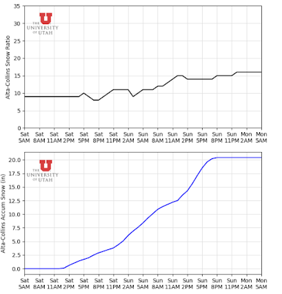
Storm Total Forecast Snow (8pm Saturday - 8pm Sunday)

Alta - 16 - 22 inches

Brighton - 16 - 22 inches

Deer Valley - 14 - 18 inches

Park City Mountain Resort - 10 -14 inches

Snowbird - 16 - 22 inches

Solitude - 14 - 18 inches

Note - When we as Atmospheric Scientists forecast, we are not so much making predictions that a certain amount of snow will occur but more forecasting the probability that various thresholds will be reached. For example, I forecast 14 - 20 inches for Alta. From a probabilistic standpoint, there is a 75 percent chance Alta exceeds 14 inches and a 25 percent chance Alta exceeds 18 inches. When you see the ensemble plumes (such as the one below), they are not necessarily telling us what will happen but more so showing the range of possible outcomes. For this event, the range of possible outcomes in the Short-Range Ensemble Forecast (SREF) is roughly from 8 inches to 22 inches through 8pm Sunday 1/15 (~16/00Z).

SREF Ensemble Plumes for Accumulated Snow at Alta-Collins, valid 00Z 1/15 through 12Z 1/18. Image courtesy the Department of Atmospheric Sciences, University of Utah.


Long Term Forecast

As we look into the longer term, another weak storm looks to come through late next week after the Tuesday brush-by. We will watch these systems and write more detailed forecasts as they approach. After that, it is looking more likely that we will see a drier pattern set up over Northern Utah through the end of the month. Note that drier is simply relative to our climatological snowfall and recent events and does not necessarily mean dry. It is likely that during this upcoming period, temperatures will be slightly below normal with the chance for occasional precipitation.

ECMWF Weekly 7-day Precipitation Anomaly, valid 00Z January 24 - 00Z January 31. Image courtesy of Weatherbell.


With the last month bringing seemingly endless storms, our mountain employees and snow safety teams have been working around the clock to keep us safe. Be sure to thank a patroller or UDOT employee today!

GEFS 500mb Geopotential Height Anomaly Forecast trend from the past 10 model runs, valid 06Z Saturday, January 28 (11pm MST January 27). Image courtesy of Tropical Tidbits.


Backcountry Comments

Avalanche danger is elevated in the backcountry so be sure to head over to our friends at the Utah Avalanche Center.

Saturday, January 14, 2023

Guess what! More snow on the way!

TL;DR:

The nice weather we've been having over the past few days will break tonight as another storm makes its way into the state. This storm will be smaller than earlier this week, but substantial accumulation is likely in the mountains. The NWS has issued a winter storm warning starting this afternoon and continuing through Sunday evening. 

Nowcast:

We have high clouds over the state currently.

GOES-West image taken at 12:06 MST. Courtesy: College of DuPage ATMOS

Mountain temperatures sit above freezing at the base and below freezing at ridgeline. I expect temperatures to cool off throughout the day. 

Short-term:

A storm will impact the region starting this afternoon/evening and continue through Sunday evening. SREF ensembles show snow accumulation beginning around 6pm MST. The period of highest accumulation will be tomorrow morning around 3am MST. The HRRR shows snow showers stopping around 8pm MST on Sunday. 

As far as accumulation goes, the HRRR LCC guidance shows 20 inches for this storm, and the GFS guidance shows 13 inches. The main difference between the two models is that the GFS has the Wasatch only receiving 1 inch of water, while the HRRR shows 1.75 inches.

HRRR LCC Guidance. Courtesy: UofU ATMOS
Given this discrepancy, the ensemble runs could help. The SREF is made up of two ensemble runs, the ARW and the NBM. All ARW members are sitting around 20 inches, while the NBM members show less than 15 inches. The ARW is based on the WRF model, while the NMB is a suite of many models. There are advantages to each, but this is where the discrepancy between the two outputs come in. See the ensemble output below. 

SREF ensemble output. Courtesy: UofU ATMOS

Given all of this, my accumulation estimate would be a 75% chance of total accumulation >15 inches with a 25% of accumulation of 20 inches at high elevations. 

Long-term:

After the storm this weekend, 2 more storms will impact the state, but they don't look all that promising in the Wasatch. The first storm will come in late next week, but the highest accumulation will be in southern Utah. The second will pass through next weekend and could provide some accumulation in the Wasatch; we'll have more for you next week. 

From a pattern viewpoint, a ridge builds off the West coast after the 2nd storm mentioned above. Right now, it doesn't look too strong, but time will tell. There could be a break to the active pattern we've been in for the past 5 weeks.