TL;DR -
Light dusting overnight last night. It should clear out for the rest of the week. Chance for snow Friday and Saturday. The main storm will come on Sunday night/Monday morning. Temperatures will remain quite cold through the rest of the week as the flow remains northerly.
Nowcast -
Up in the mountains right now, we've got soft snow, excellent riding conditions, and frigid temps. Currently, temperatures are sitting at 13 degrees at the trailheads and 3 degrees at ridgeline. Windchill will bring these into the negative range. It looks like scattered clouds up there today. I expect this to continue throughout the day.

Short-term -
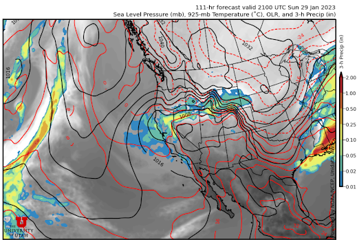
We have some interesting weather coming in this weekend. The first storm will be relatively weak and should come on Friday afternoon. There will likely be weak snow throughout the weekend, with the majority of potential mountain snowfall coming on Sunday evening / Monday morning. This storm coming late in the weekend doesn't look like much, but it has a really interesting setup. I've never seen anything like this, but a strong pressure gradient setting up right over the Wasatch will provide lift. As this isn't directly associated with a trough, it will be pretty stationary. Snowfall totals could be substantial. Below is the GFS output for Sunday afternoon.
As this storm is really due to this pressure gradient, there is considerable uncertainty about how it will work out. This can be really seen in the ensemble spread.

I mean, 13-55 inches. That's wild. Most members agree that the accumulation is over 20 inches, so 15-20 seems like a safe bet. Any more than that might be wishful thinking. We'll know more as the week progresses, so stay tuned.
Long-term -
We've had a pattern shift over the past week. There is now a blocking ridge off the West Coast that limits the strength of the storms we can get. It's looking pretty meager after this one, as any storm that wants to make its way toward us is weakened too much by the ridge off the coast. I would prepare yourself for a break in the snow. Mother Nature wants to give the ski resorts time to dig themselves out.
All this clear weather and snow means it could be time to get out deeper into the backcountry. As usual, please head over to our friends at the UAC and have a good plan before heading into the backcountry.
No comments:
Post a Comment