Wednesday, February 28, 2024

Rollercoaster ride

 TL;DR:

Today will be sunny and warmer, tomorrow will be cloudier but still warm, and the weekend will bring snow.

  Nowcast:

We're on a temperature rollercoaster right now! Temps took a plunge yesterday, but are now steadily increasing, as evidenced by the Hidden Peak temperature graph:

Hidden Peak temps, courtesy of the National Weather Service

They will continue to do so today under sunny skies; expect summit high temps in the mid-20s °F.

 Short-term:

Tomorrow will feature even warmer temperatures (think summit high temps around 30 °F) but cloudier skies.

 Long-term:

The rollercoaster starts its exciting descent this weekend as cold temps and storminess are in the forecast. Right now, models have snow starting Saturday morning and continuing through Sunday evening; it's looking like an 10-16" storm at the moment, but we are still a couple days out and model variability exists...as it always does :). Make sure to check back here at Utah Ski Weather over the next couple of days as we fine-tune the totals...


Have fun skiing the resorts, or if you choose to venture into the backcountry, make sure you have proper training and equipment and know before you go. For the avalanche forecast and other avy-related resources, visit utahavalanchecenter.org.

Monday, February 26, 2024

More Powda

TL;DR:

    The warm air will leave the area this evening with the arrival of our next storm. Flurries are to begin this afternoon with a strong cold front kicking the storm into action around midnight. Mountain snow totals of 10-20" possible. 

Nowcast:

As we eagerly await the snow tonight, we are seeing warm temps in the mountains with cloudy skies. Mountain bases are reaching above freezing with ridgelines dipping just slightly below freezing. Winds are blowing out of the West, reaching up to the mid 30mid-30s's with strong gusts breaking up to even 50mph. Temperatures will continue to drop throughout the day as this evening's storm moves inland. 

Short Term: 

Beginning late this afternoon, the trough that is situated over the West Coast of the U.S. will move further inland, bringing with it some prefrontal snow to kick the storm off. the initial snow will be brought by the warm moist air from the SW. In the GFS run below valid at 7:00 tonight the strong injection of moisture can be seen in the bottom right panel. One feature to note is in the bottom left panel the 700 mb temperatures show warm temps accompanying the moisture. That said, expect lower SLR to start the storm. In addition, the closed low that sits off the West coast is highlighted, how this closed low merges with the main trough feature will help to determine how this storm plays out. 

U of U Dept. Atmospheric Science

Around midnight, the upper-level trough will reach Northern Utah, bringing with it the cold air and NW flow. The tight packing of the dotted isotherms (lines of constant temperature) in the bottom left panel below is the cold front. Depending on the timing of the arrival of the cold air in relation to the moisture will be a controlling factor in how much snow this storm delivers. Midnight tonight, the storm will really begin to pick up, and with the cool temps, SLR will begin to increase. 

U of U Dept. Atmospheric Science
 

    The brunt of the storm will pass by 10:00 Tuesday, but light flurries will continue through the day. With the warm start to the storm and temperatures dropping rapidly with the cold front, the storm should come in relatively right side up. In addition we will have to wait and see if the NW flow that will follow the cold front will help to bring some lake effect snow on the back end of the storm. For the mean time, if there is lake effect snow it will be aimed primarily at the Northern Wasatch. 

    The models currently are showing an interesting spread regarding snow totals, We will have to wait and see how the timing of the storm plays out. That said, expect double digits of snow; the upper Cottonwoods could see 10-20" of snow. 

Long Term:

    Following this storm an impressive trough will build off the NW coast priming us for another storm set to arrive this weekend. Looking at the bigger picture, it appears we are in a very progressive, active pattern that will continue for the foreseeable future. 

Backcountry Comments:

    If you plan to travel in the backcountry make sure you are equipped with not only the gear but also the knowledge. Check-in with our friends over at the Utah Avalanche Center for avalanche forecasts, observations, and all things avalanche. 

Wednesday, February 21, 2024

We love snow

 TL;DR:

Valley rain and mountain snow persist through tomorrow. A ridge will follow, bringing warm temperatures over the weekend. A chance for more snow and cold temperatures exists for early next week.


Nowcast:


Our current snowpack is doing better than average! Snowbird is sitting at 142% of the mean. And with continued snow, we can hope this number keeps going up.

SWE from the Snowbird SNOTEL site

Temperatures in the valley are currently in the lower 40s. We can expect to warm to around 45 degrees this afternoon before dropping with our low in the mid 30s expected tonight. Our high temperature for the day was most likely reached last night right after midnight when we hit 47 degrees. Showers are expected throughout the day in the valley until 3am. After 3, a chance of snow is possible. The Wasatch are expected to continue getting snow through tomorrow.


Short term:


An upper level trough is the forcing mechanism that is currently bringing active weather to our region. This trough is associated with a cold front and PV anomaly that are driving our precipitation. This system is also associated with high precipitable water for our region this time of year, with values of PW = 0.42 inches as of 6am this morning.

Sounding data from SLC airport this morning at 12 UTC.

As this trough progresses eastward, it will continue to produce mountain precipitation through tomorrow. I am expecting snow totals for the Cottonwoods to come in around 9.5 inches through tomorrow evening, with more of the snow occurring during the day today. Sustained winds around 16 mph are expected through today and tomorrow morning in the mountains. By Friday, a ridge will build into our region bringing back warmer temperatures for the weekend.


Long term:


This ridge is accompanied by a stationary closed low positioned over the eastern Pacific off the coast of California. The ridge will continue to be positioned over Utah until early next week. The models are producing a deep trough with high PV values coming down from the Alaskan coast that will overtake the ridge. This trough has the potential to bring mountain precipitation and cold temperatures to Utah. Continue to check in over the week to see how this storm develops.

500-mb heights valid for 15 UTC Feb 25th. The stationary closed low is seen over the Pacific with the deep trough and strong PV values progressing down the PNW coast. 


Backcountry comments:


Current avalanche danger is considerable above 8,000ft and moderate below. If you will be traveling in the backcountry make sure you have the proper equipment and know before you go. For the whole avalanche forecast and all things avalanche head over to our friends at the Utah Avalanche Center.


Courtesy 

Ashley Evans


Tuesday, February 20, 2024

Lotta Watah

TL;DR: Lots of wet snow has fallen around the Wasatch. If this keeps up, we (Alta Collins) might break the February SWE record going back to 1980. 


Nowcast:

Snow has tapered off, for now. Looking around the Wasatch, Powder Mountain appears to be the winner from yesterday / last night's storm reporting 13" of snow. Alta on the other hand, reported 8" of new snow on 1.25" of water. That's 15% snow right there, which is dense in all states, but particularly ours. 


Data from MesoWest

A current break in the action: Alta.com

Short Term:

Winds will remain from the SW through tomorrow, with snow expected to flurry on and off throughout today. Sometime around 5pm local, the snow will pick back up bringing 6-10" by tomorrow morning. This looks to be another mild storm, so we can expect more of the same in terms of SWE. I for one have gotten to ski some of this dense snow as of recent, and it rides quite well. 

Long Term:

Things are expected to dry out and stay calm through the end of the week and into the weekend. Be sure to continue checking Utah Ski Weather to track the next storm! 


Backcountry Comments: 

Colors are changing (more yellow, less orange), but we're still looking at lots of new snow with high winds. Don't be fooled by the healing (although not absent) PWL, and stay alert to recent and changing conditions. 

If you plan to travel in the backcountry, head over to the Utah Avalanche Center to be best prepared. As always, travel with the right equipment and good communication. 

Monday, February 19, 2024

Break in the Action

TL;DR: Today is a break in the action with a mix of sun and clouds, before our active pattern kicks back into action through Thursday.

Nowcast: Under a fairly strong southerly flow at the highest ridge-lines, mid-day mountain temperatures are warm, ranging from the low to mid 30s at resort base level to the 20s on the upper elevation ridge-lines. All resorts are reporting new snow in the past 24 hours, with Brighton leading the way with 9 inches, though that all fell during the day yesterday. For today, expect a mix of sun and clouds, with cloud cover increasing during the day and the potential for some snow showers in the afternoon. Here is Alta's Mt. Baldy cam at 11:15 a.m.

Source: Alta Ski Area


Short-term Forecast: In a pre-frontal southwesterly flow environment, we can expect snow during the day tomorrow.

Source: University of Utah Department of Atmospheric Science

Mountain crest level temperatures tomorrow will be around -5 °C (bottom left plot above), which is fairly warm for Northern Utah, so we can expect dense snow and rain below around 6,500 feet.

A frontal passage finally occurs on Wednesday morning at around 9:00 a.m. local time, causing the winds to shift to more northwesterly (bottom left plot below).

Source: University of Utah Department of Atmospheric Science

Temperatures on Wednesday will fall, yielding higher snow-to-liquid ratios. However, there is a bit less moisture to work with on Wednesday. By mid-week, we could be looking at an additional 15 inches of fairly heavy snow.

Mid-long Range Forecast:

We clear out for the weekend with ridging taking control over the intermountain west. This will yield warm temperatures and bluebird conditions for exploration.

Enjoy the new snow!


Friday, February 16, 2024

Light snowfall today and Sunday, potentially active next week

TL;DR:

 Expect light snowfall today and Sunday. Next week is worth keeping an eye on...

Nowcast:

 It's cloudy and snowing lightly in the mountains right now; we can see this from Snowbird's Little Cloud Bowl webcam:


Little Cloud Bowl webcam, courtesy of Snowbird

 Expect the snow showers to continue throughout the day, with somewhat gusty winds and summit high temps around 20 °F.

Short-term:

 In terms of snowfall, we'll see more flakes fall on Sunday; this shouldn't be a blockbuster storm by any means, but should provide some soft turns. Otherwise, we'll see seasonal to above-seasonal temps, light winds, and partly to mostly cloudy skies.

Long-term:

 I like the look of the model plumes for the next seven days:


Model plumes for PCMR Summit, courtesy of the U of U Dept of Atmospheric Sciences

 You can see the snow today, as well as the weak wave of moisture on Sunday. Then things get interesting around Tuesday of next week and the model plumes just sort of take off, suggesting an active workweek... It's definitely worth watching!

Backcountry comments:

 Have fun skiing the resorts this weekend, or if you plan to travel in the backcountry, make sure you have the proper equipment and know before you go. For the avalanche forecast and many other avy-related resources, head over to our friends at the Utah Avalanche Center.


Monday, February 12, 2024

What a stellar ;) weekend!

TL;DR:

After wrapping up an excellent weekend in the Wasatch Mountains, we get a break from snow as high pressure has taken over. Expect sun and higher temperatures over the next few days. We should start seeing some cloud cover and light flurries in the mountains on Wednesday-Friday. Our next large storm could be next week.

A beautiful morning in the Wasatch on Saturday.
Nowcast:

Currently, skies are clear, and mountain temperatures sit around 18 degrees at the bases and 13 degrees at the peaks. Today should be another sunny day in the mountains with temperatures reaching the low-mid 30s at the bases and mid-20s at the ridgelines. Solar aspects should get much warmer. Winds should be moderate, with sustained 20mph & gusts of 30mph at ridgelines. 

Courtesy: Alta Ski Area

Short-term:

Over the next week, a small, short-wave trough will pass to our north. This will bring increasing cloud cover starting Wednesday. I expect snow accumulation associated with this storm, around 4-6 inches through Friday, with possible increased accumulation in upper LCC. The bulk of the accumulation should happen on Thursday, and I expect the winds to stay relatively consistent at ~20G30 from the west.

Long-term:

The GFS has a stronger trough stalling on the coast of Northern California in the middle of next week. If this pans out, it would be a larger storm that would bring significant accumulation totals. However, the ECMWF does not have the trough as strong or show it stalling at the coast. I expect this all to change; check back for updates on these storms. 

Sunday, February 11, 2024

Bit of a break from snow

 TL;DR:

After several days of snow, we're going to have a quiet period for the weekend and early next week before more snow is scheduled to return to the valley.

Nowcast:

High in the upper 30s, low in the lower 20s. Not much going on, but at least air quality is pretty good after all the snow drove out the bad air. 

Short term:


Snow in Northern Utah Wednesday night/Thursday morning from https://www.tropicaltidbits.com/


Expect sunny conditions over the next several days leading up into Valentine's Day. Temperatures should be around the mid 40s for highs and low 30s for lows. Good time to have a picnic, if you can find a park without any snow on it. However, make sure that picnic is finished by late evening on Wednesday, as more snow is expected to arrive.


Long term:

Precipitation and Rain models for the U. https://weather.utah.edu/

As the trough hits on Wednesday/Thursday, some snow or rain could happen in the valley. It's too early to see what the snow line will be here in the valley, but hopefully the mountains will get some more snow. Based on all the different models showing different values, it's hard to say with any certainty. We'll make sure to keep you updated. 

Backcountry comments:


If you will be traveling in the backcountry make sure you have the proper equipment and know before you go. For the whole avalanche forecast and all things avalanche head over to our friends at the Utah Avalanche Center.


Thursday, February 8, 2024

65 inches, 8 days

TL;DR: Utah wakes up to more snow, again. Chances of weak disturbances through Saturday.


Nowcast:


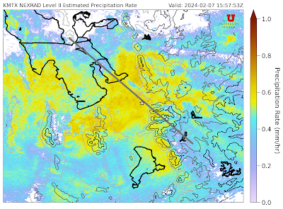
Precipitation rates have slowed down, but it's still snowing at Alta. The current snow stake shows just about 2", but this storm was nothing short of spectacular. 

Things really kicked off Tuesday night, and as yesterday's report showed, we all woke up to 7" of new snow atop Little Cottonwood Canyon (LCC). It didn't stop though, and MesoWest shows an additional 13" of snow that fell between 07:00 and 15:00 local. It snowed 2" an hour, for 5 hours straight between 07:00 and 12:00 local. Then after just an hour lull, it picked back up to deliver another 6" overnight for a total of 26" of new snow since Tuesday night. That's awesome! 

Even the great 
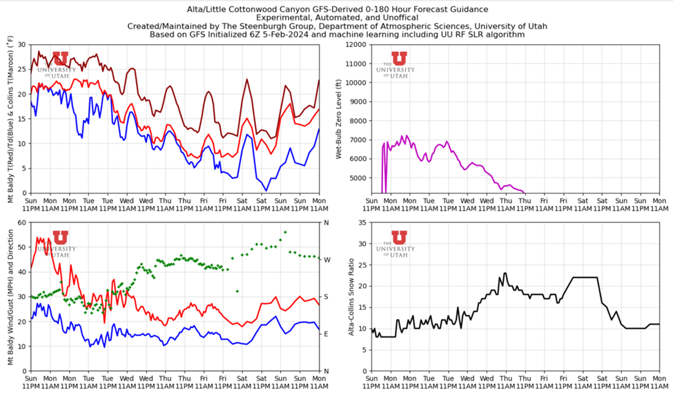
Professor Steenburgh predicted a complicated, and unpredictable snow week. And he was right. Here is what the HRRR called for up Little Cottonwood Canyon, initialized yesterday. You can clearly see Alta well outperformed even the latest model, and scored closer to 17" of snow (instead of the 10" projected).  

The most notable shift I saw in yesterday's storm, was when the winds switched, originally blowing from the south, and then the west northeast. It appears that this was felt heavily through much of the Wasatch. 

Strong southerly winds per GFS valid 0600 UTC Wednesday, February 07

Winds shift to W-NW: GFS valid 0000 UTC Thursday, February 8

It's safe to say the skiing today should be excellent, although perhaps not as excellent as yesterday was. 

Short-Term:

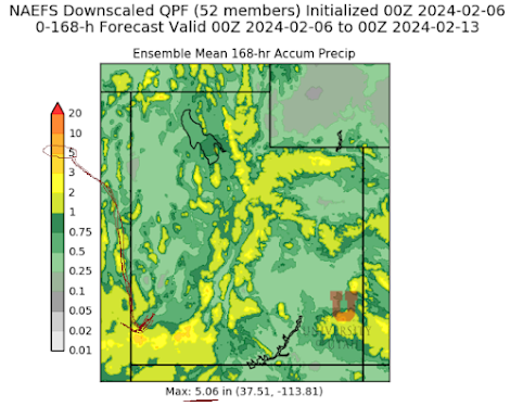
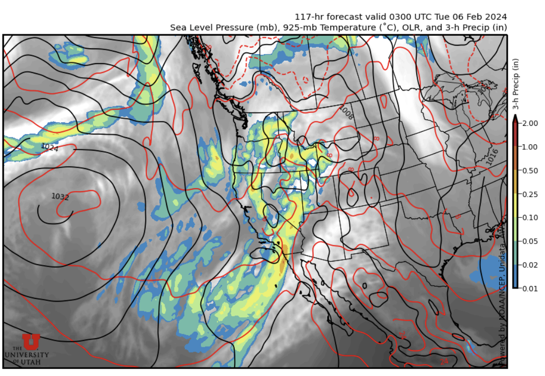
There's still moisture available in the area, however things are more scattered than yesterday. This is easily seen in the NAEFS plume shown below. Winds will shift back to the south during the day today, and then switch back to west northwest later into the evening, which always ups the odds for places like LCC.

The trough remains above Utah, however the concentrated low pressure will sweep through the southern portion of our state, which will limit totals up north. Nevertheless, snow is still in the forecast and that is a good thing. 

More snow in the forecast. Forecast for Saturday: traffic-y 


Long-Term:


The trough mentioned above is expected to depart by the end of day Saturday, bringing drier, albeit colder, conditions pushing in from the northwest. Then, a ridge is forecasted which should mean bluebird days Sunday and Monday. Check back in then! 

Backcountry Comments: 


There was a natural that dusted a party in West Porter, and a 2' deep avalanche observed just above the entrance into Jaws. 

If you plan to travel in the backcountry, it is well advised to avoid being near any avalanche terrain. As always, be sure to travel with all the right safety equipment, have a solid entry and exit plan, and keep atop all things at the UAC

Wednesday, February 7, 2024

Deep February Continues

TL;DR: A wave of heavy snow will help snow stack up today. Snow continues tomorrow in a northwest flow, with potential additional snow on Friday. Lots of snow!

Nowcast: It is snowing heavily under a southerly flow in the central Wasatch right now (10:30 a.m. Wednesday). Radar imagery from the KMTX radar shows precipitation rates > 0.6 mm/hr in the mountains and adjacent valley:

Source: University of Utah Department of Atmospheric Science

This is falling on top of the 6-9" that the resorts received yesterday. Today should feature excellent midweek skiing.

Short-term Forecast: The flow will shift to west-northwest as the day progresses, leading to a decrease in temperatures and an increase in snow-to-liquid ratios. This is a perfect storm scenario, with lighter snow falling on top of the heavy snow that fell yesterday and this morning. One model, the HRRR, calls for an additional 10 inches of snow to fall at Alta today, with snow-to-liquid ratios tending upwards.

Source: University of Utah Department of Atmospheric Science

Expect snow to taper off later on Wednesday and into Thursday, although the pattern will remain unsettled and additional flakes could fall during the day on Thursday.


Mid to Long Range Forecast:

Models call for an additional follow-up wave of snow during the afternoon and evening on Friday. Here is the GFS model valid at 0300 UTC on Saturday (Friday evening).

Source: University of Utah Department of Atmospheric Science


Under a west to west-northwest flow, and cold mountain-crest-level temperatures near -11 °C (bottom left panel), we can expect moderate precipitation rates in northern Utah (upper right). 

Models hint at ridging through the weekend, bringing clear and calm weather to northern Utah.

Enjoy all the new snow!

Backcountry Comments:

If you will be traveling in the backcountry make sure you have the proper equipment and know before you go. For the whole avalanche forecast and all things avalanche head over to our friends at the Utah Avalanche Center.

Tuesday, February 6, 2024

Southwest


TL;DR: Is Southwest the best? 

(Probably not, but it's happening) 
I picked this desert theme image to suit, and see the atmospheric river of water vapor in the upper atmosphere:

Goes West, Low Level Water Vapor (Channel 10) via https://weather.cod.edu/. For more specifics about Chanel 10, see this great resource: www.star.nesdis.noaa.gov/goes/


Hawaii (bottom left) to Utah (top right). 


Nowcast: 

Current across Utah. See the red 'double dots' in southern Utah? They are 'continuous rain observed'. Similar observations throughout the region. No weather was observed at KSLC, but the light pink denotes a storm warning from the NWS. Image via https://aviationweather.gov/gfa/#obs. Radar reflectivity overlaid as well. Great Photo. 


Brighton (Great Western) at 1030am Feb6: https://brightonresort.com/conditions

Short term: 


Wetness incoming from the southwest to the Wasatch. Expect moisture to hit our door steps later this afternoon, with continued precipitation through Wednesday. 

More south will likely equal "more better", but the high terrain throughout the State could help squeeze the moisture out, and more importantly, keep the freezing levels low. 

Cropped NAEFS (North America Ensemble Forecast System) courtesy https://weather.utah.edu/index.php?runcode=2024020600&t=naefs&d=PP&r=UT showing MEAN precipitation (inches-water-equivalent) across the state for 168 hours (7 days). I think the 5" max is down south.  


Long term:

Changing pattern to hit the region Thursday, with temperatures dropping as the current system moves passed us: 

10 Day forecast (single model run) via https://spotwx.com/

Backcountry comments: 

Expect avalanche hazard to increase as new snow and precipitation collects on a sandwich of buried weak layers. Almost a Canadian setup, surface storm snow hazard is the immediate concern. Buried dragons persist below, capable of producing large avalanches if triggered from loading or the unfortunate 'sweet spot'.  


If you will be traveling in the backcountry make sure you have the proper equipment and know before you go. For the whole avalanche forecast and all things avalanche head over to our friends at the Utah Avalanche Center here: Utah Avalanche Center

Monday, February 5, 2024

Stormy Week Ahead

TL;DR: A strong storm in the Pacific will penetrate inland today bringing snowfall to Northern Utah. The longwave trough associated with this storm will affect most of the Southwest United States through Wednesday. Another trough merges into the existing longwave later in the week bringing more chances for snowfall. The longwave trough affecting us for the first part of this week is bringing warm moisture from our south which will continue to keep temperatures rather warm and snow levels around 6000-6500 ft.  

Nowcast: It is currently 32 F at the base of Alta and 23 F at the top of Collins. Expect winds to remain moderate throughout the day from the South. Wind magnitudes are trending downward throughout the week. 


Short-Term: A longwave trough will bring snowfall to Wasatch ski resorts today and rain to the valley. Model spread is quite large for this storm as it is difficult to tell where the best dynamics will occur. Snowfall is expected to start Monday morning and will continue throughout the day. Snow accumulations range from 4-8” by Tuesday morning for Wasatch Resorts. Tuesday will see a brief break in snowfall until it starts back up late Tuesday night. Snowfall will continue on and off through Wednesday. At the 700 mb level, southerly winds will dominate the region Monday-Wednesday, then switch to westerly on Thursday.  

(Univ Utah: https://weather.utah.edu/. Time Height plot showing the dry break in the weather we see Tuesday during the day. Wind barbs show southerly wind and the blue line shows a high snow level.) 

Long-Term: Another trough dips into the region on Thursday and merges with the existing longwave. This extends the period of unsettled weather through the rest of the week. It is difficult to tell where the best dynamics will fall within this large system, so expect spotty snowfall for the remainder of the week as this low-pressure system migrates through. Snow levels dip down to the valley floor by Thursday night as temperatures trend downward throughout the week. 


(Univ Utah: https://weather.utah.edu/. Top Left: Temperature, Top Right: Wet-Bulb Zero level, Bottom Left: Wind, Bottom Right: Snow to Liquid Ratio. This product shows temperatures dropping throughout the week and strong southerly winds switching to westerly by Thursday with decreasing magnitude. Snow levels can be interpreted by Wet-Bulb zero levels, snow levels will be ~500-1000ft below.)

Backcountry Comments: With new snowfall and strong winds make sure you knowbeforeyougo and visit UAC before heading into the backcountry. 


Sunday, February 4, 2024

32,000-foot dispatch

TL;DR:

Bonus snow fell this morning, and paired with (relatively) warm temps and sunshine, should make for a great day today. Looking ahead, an active week is on tap with snow and steady snow accumulation throughout the week. Snow quality will improve as the week goes on.

Nowcast:

I'm checking out the world from an airplane this morning, and I was pleasantly surprised to learn that the Wasatch got some cool bonus snow last night! Central Wasatch resorts generally got around 6". Yep, even Park City:


PCMR snow stake, courtesy of Park City Mountain 

It's chilly in the mountains this morning; Mesowest is showing Central Wasatch summit temps in the single digits and most bases in the teens:


Mesowest weather stations as of 0740 (courtesy of Mesowest)

And the GOES-West satellite is showing mostly clear skies over our area:


GOES-West satellite image, courtesy of NOAA

Temps will climb out of the single-digit ditch today and should reach the 20s °F at summits and the 30s °F at bases. With the sun and new snow, it should be an absolutely awesome day!

Short-term:

An atmospheric river is pounding California right now, and it's this system that will be providing a good deal of the moisture we're getting this week.

Looking at the model plumes, you can see that it's going to be an active week, but the snow will come slow and steady rather than in one single big dump. 


PCMR Summit plumes, courtesy of the University of Utah Dept of Atmospheric Sciences

It's quite challenging to pick out the best time to grab deepness because the models seem to be disagreeing more than usual right now; if I had to preliminarily throw out my guesses for the best powder days, I'd say Wednesday through Friday mornings could be good. But again, that was me guessing... although that's just how meteorology works sometimes ;). I'll say this as a blanket statement: expect a generally cloudy and snowy next few days with temps gradually dropping throughout the week.

Long-term:

After this week, things start to look dry, so I'd recommend grabbing your powder skiing now...

Backcountry comments:

Keep an eye on the danger roses this week because the active pattern will once again stress our snowpack. If you plan to travel in the backcountry, make sure you have the proper equipment and know before you go. For the avalanche forecast and many other avy-related resources, head over to our friends at the Utah Avalanche Center.

Thursday, February 1, 2024

Snow making a return

  TL;DR:

Snow will make a return after a quiet and warm week.


Nowcast:


tropicaltidbits.com

As of the writing of this post, it is cloudy with precipitation moving in from the west. The Sierra Nevadas could get hit with multiple feet of snow from an atmospheric river. This precipitation will move into the area starting on Friday. Temperatures are warmer than average with base temperatures of 37 degrees being reported. It is currently 27 degrees at 10,000 ft.  


Short term:


Snow should begin falling later today and should continue producing snow throughout the weekend. About 5-8 inches of snow can be expected from this system before the next system moves in early next week. Temperatures will also fall to values closer to climatological averages. 


Long term:


weather.utah.edu


Another atmospheric river is forecast to impact California. This precipitation should spread inland early next week and will result in accumulating snow in the mountains. It is too early to tell how much snow can be expected but there is guidance that suggests the system will produce precipitation over a few days. 


Backcountry comments:


If you will be traveling in the backcountry make sure you have the proper equipment and know before you go. For the whole avalanche forecast and all things avalanche head over to our friends at the Utah Avalanche Center.