TL;DR:
Same-Same with some Dusting - Stretch the Legs
Nowcast:
 |
| Surface Analysis courtesy https://www.aviationweather.gov/progchart/sfc valid 1335 UTC (0635 AM MTN) - High pressure to the west and north of Utah at the moment influence our current break in the storm |
 |
| Current Temperatures (F) courtesy of https://mesowest.utah.edu/cgi-bin/droman/mesomap.cgi?state=UT&rawsflag=3 mid 20s near University of Utah campus, mid teens around the ski hills of Big and Little Cottonwood Canyon |
 |
| Looking South from UofU campus - 0730 MTN today |
Relatively calm conditions around the valley, light NW winds and broken clouds (5/8 to 7/8 of the cloud deck obscures clear sky, see the small clearing from photo above).
The rest of today should look similar to this morning, add some sunlight and thinning clouds while temperatures increase slightly. Partly cloudy (or partly sunny? half full half empty kind of question) throughout the day. Potential for light snow showers as the surface air is pushed up and lifted over the Wasatch, marginal accumulations expected.
Short term:
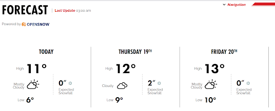
The 60-hour forecast loop above shows promising conditions for single digit inches in the mountains on Thursday. Alta is calling for 2" as a low-pressure system tracks NW to SE from Idaho.
 |
| Alta/OpenSnow Predictions for Thursday.. Wait till the Marketing department gets their hands on this. Courtesy https://www.alta.com/weather |
Long term:
My attempts to track a trough that passes through Utah this weekend is shown in the GIF (hard-G, "GH-IF") below. The trough will likely lead to unsettled weather (intermittent precipitation, light snow accumulations) through the mountains and cloudy to overcast skies. There could be a punch of precipitation (1-2") for the mountains on Sunday.
As the high pressure stays parked in the Pacific the intermittent and light snow could continue through early next week.
Stretch the legs, maybe wax the skis, tighten your straps and bindings.. it's been a great couple of storms the last while.

Upper level winds, forecast from GFS and Pivotal Weather https://www.pivotalweather.com/model.php?m=gfs&p=200wh_nb&rh=2023011800&fh=loop&r=na&dpdt=&mc=
Backcountry comments:
Some big storms have deposited some load onto the snowpack, the experts will be monitoring results and observations from the recent storms.
If
you will be traveling in the backcountry make sure you have the proper
equipment and know before you go. For the whole avalanche forecast and all
things avalanche head over to our friends at the Utah Avalanche Center
here: Utah Avalanche Center

No comments:
Post a Comment