Wednesday, January 31, 2024

Blue Today Gone Tomorrow


TL;DR:  BLUE SKIES GONNA.. wait.. SNOW! late Thursday, into Friday/Saturday

Nowcast:

KSLC 312047Z 3121/0124 17015G25KT P6SM FEW200
  FM312300 17010KT P6SM SCT100
  FM011500 16006KT P6SM BKN060 BKN100

What more do you need?

At KSLC (airport), effective Jan31, 2047z (13:47 local), winds are expected to be 15 kts from 170degrees (South-SE), gusting to 25, with visibility exceed 6 miles and few clouds (scattered) to 20,000 ft. 

Basically, this: 
Looking EAST, my office, campus. 

The DeMoisy Express is looking nice at Snowbasin. Gloves optional on the skidoo today: 

Short term: 


"Heyyyy - I can see my house from here!" 
GOES-WEST, IR, with 500mb auto Analysis/Annotations
via NEXLAB

The blob of colours from the satellite loop show a southwest flow coming onshore and making it's way inward to Utah, likely hitting southern Utah first and could bring valley rain with mountain snow. 

The NAM has mountain-snow starting mid to late afternoon tomorrow (Thursday) with an inch of the good stuff. Friday into Saturday is continued precipitation with 5-6 inches likely: 

SpotWx output for the NAM (North America Model) https://spotwx.com/products/grib_index.php?model=nam_awphys&lat=40.60457&lon=-111.63963&tz=America/Denver&label=

The experts have issued a Forecast through 5PM Friday with light-orange over the Wasatch Front (say 8ish inches?):

NWS Probabilistic Snow Amounts: https://www.weather.gov/slc/winter

Long term:

The spinning blob (upper portion of satellite image) will continue to bring SW flow into Utah after the weekend, let's hope freezing levels stay low and it collects as snow. 

Backcountry comments: 

Yellow-Yellow-Yellow (Moderate) for the Salt Lake Mountains: 


Keep your eyes peeled on those solar aspects and be mindful of the persistent weak layer. 

If you will be traveling in the backcountry make sure you have the proper equipment and know before you go. For the whole avalanche forecast and all things avalanche head over to our friends at the Utah Avalanche Center here: Utah Avalanche Center

The wait is almost over!

TL;DR:

There is a ridge over Northern Utah, and we are experiencing elevated temperatures, high pressure, and poor air quality. This will change here shortly as a long-wave trough will bring moisture and instability back to the Intermountain West. 

Nowcast:

The past few days have felt like spring in the valley and the mountains. We've seen uncharacteristically high temperatures over the past few days, with some ski areas reaching well above freezing air temperatures even on north-facing aspects. Just a drive up LCC shows all the avalanche activity on the solar aspects. It will be another warm day up there. UofU LCC guidance has the top of Mt. Baldy reaching ~38 degrees F today. Take some time to go ski some slush and enjoy the sunshine. 

Courtesy: Alta Ski Area

Short-term:

Over the next few days, temperatures will slowly decrease, and high cloud cover will increase as the coming storm begins to impact the region. Currently, the GFS shows two periods to the storm. The first, will come in from the north and I expect snow at Alta to start Thursday night. Temperatures will continue to drop throughout this first period. The GFS has temperatures dropping down to the single digits at the top of Mount Baldy on Saturday evening. For this initial period, we could see 8-13 inches. 

The second period of intensification will come after the storm tracks down the west coast and gets reinvigorated by the passage of a short-wave trough. During this period the flow will be southernly and integrated vapor transport (IVT) will be high, but more pointed south of the Wasatch. See the IVT for 0 UTC on Wednesday below.

Courtesy: UofU ATMOS

Temperatures will be higher with this second period with the LCC guidance sitting around 20 degrees at on Mt. Baldy for Monday-Wednesday. Below is the GFS LCC guidance snow accumulation.

Courtesy: UofU ATMOS

This second storm will depend largely on where the IVT path lines up in relation to the Wasatch. When we've seen storms like this in the past, it usually is either very hit or miss. I think anywhere in the 15-20 inch range on the storm is a safe bet. 


Long-term:

We're getting pretty far out with just the culimation of this storm. The GFS has some light precipitation sticking around in the area throughout most of the week next week. After that there doesn't seem to be much of a pattern that sets up. Check back in with us after the weekend and we'll have a better idea. 

Tuesday, January 30, 2024

Just several more days of bad air

 TL;DR:

Warm and inversion building until Friday, when low-pressure and precipitation will clean up the air. 

Nowcast:

Surface temperatures in the valley/Wasatch Mountains. From https://www.wrh.noaa.gov/map/


Highs in the upper 40s and even lower 50s throughout the Salt Lake valley. These higher temperatures can be attributed to El Nino conditions over the Pacific Ocean, which brings warmer, drier conditions to this part of the country. As the high-pressure ridge continues to sit over Utah, air quality will get worse due to the inversion building up. As you can see by the graph below, which measures PM 2.5 aerosols, the air quality is getting worse. Once the next system arrives, the air should be cleaned up by the low-pressure.

PM 2.5 Measurements from https://utahaq.chpc.utah.edu/


Short term:


These warmer conditions will carry on throughout the next several days, causing air quality to get worse. There is relief coming though, as by Thursday night/Friday morning, there is moisture coming from the west. This moisture will cause the inversion to dissipate, cleaning up the air. It should also bring some snow to the valley and the mountains. As we get closer to then, we can start to make predictions about the amount of snowfall and if it'll rain in the valleys but snow in the mountains.

Precipitation/Snow predictions at Alta. From https://weather.utah.edu/


Long term:

After the moisture on Thursday/Friday, there should be more chances for precipitation throughout the weekend and leading into next week, as atmospheric rivers will drench California and eventually make their way to Utah. This precipitation will bring relief from the inversion air and give us colder temperatures. Low 30s, upper 20s for possible highs over the next week, it's a return to winter after this brief spring intermission. This news article gives some basic information about atmospheric rivers. It's mostly focused on California, but it can be applied to Utah as well.

Backcountry comments:


If you will be traveling in the backcountry make sure you have the proper equipment and know before you go. For the whole avalanche forecast and all things avalanche head over to our friends at the Utah Avalanche Center.


Sunday, January 28, 2024

Too hot for January

TL;DR: Warm this week with a building inversion. An atmospheric river to our west should shake things up come Thursday. 

Nowcast: 

Temperatures sat in the mid to high 30's (F) this morning at 9:00 am local, and have rose all the way up to mid to high 40's as of 11:00 am local. (Sorry, I am writing this kind of late). The top of Little Cottonwood hovers around 38 F, which is rather absurd for January 28. Take a look for yourself below:

Salt Lake County / Canyons Surface Temperature at 11:00 Local: wrh.noaa

PM2.5 concentrations are on the rise as of this morning, and I'd expect this trend to continue as temperatures look to be warm in the week ahead as a high pressure ridge sits atop Utah (see second picture below). 

Short-Term:

The ridge continues to build across Utah all the way through Wednesday, and most likely Thursday. With it, we can expect low winds, warm temperatures and no snow. Temperatures in the valley will reach as high as 55 degrees F and 37 F up at Alta. We can certainly expect an inversion to build. 

The glimmer of hope comes on Thursday and Friday, when valley rain and canyon snow should push things out into the weekend. All things considered, this inversion won't last long. 

Long-Term:

Current forecast confidence suggests a sudden shift away from this week's ridge as early as Thursday. This savior comes in the form off a current atmospheric river pattern around the Pacific Northwest that will eventually move south and push away our dreaded high pressure system. 

Too early to say, but I might as well leave you all with this to inspire some hope. 

Hope on the horizon: https://weather.utah.edu

Backcountry Comments:

Lots of funky stuff to see all around the backcountry. Observations ranged from wet loose avalanches (again, see title) to skier / rider triggered avalanches. 

A few that caught my attention are this rider triggered avalanche off of Mt. Tuscarora, a variety of slides across the Flagstaff face in Days Fork, and the various pits dug around Cutler Ridge towards Ben Lomond (#1 and #2).  

Please take a look for yourself and follow the guidance from the good folk at the Utah Avalanche Center, and be sure to be prepared with the right gear and safety equipment if you plan to spend time in the backcountry. 

Saturday, January 27, 2024

A Dreaded Ridge is Upon Us

 TL;DR:

A week of high pressure is upon us. Poor air quality is expected in Northern Utah Valleys through the week.


Nowcast:


Salt Lake can expect highs near the 40s with calm winds throughout the day. A high pressure ridge has situated itself over Utah and the interior west. Warm, dry conditions can be expected to persist with this ridge. 


View of the valley looking south from campus.


Short term:


The high pressure ridge will begin to amplify overnight tonight. Even warmer temperatures are expected with this amplified ridge. Highs will be near the 50s through the beginning of next week. Valley inversions will begin to set up along the Wasatch front. Valleys with a current snowpack can expect more established inversion conditions. These inversions are expected to contribute to decreased air quality. The Utah department of air quality has issued Sunday and Monday as mandatory action days, so try to limit your time outside and carpool when you can.


Utah Department of Air quality weekend forecast


Long term:


The high pressure ridge is expected to persist through midweek. A high amplitude trough is expected to make its way inland late this week. This system will have high water content and precipitation is expected. This storm should help to mix out the stagnant air that will have developed in the valleys. There is uncertainty in the timing and water content for this storm, but check back later in the week to see how this storm develops.


Backcountry comments:


The avalanche danger in the Salt Lake mountains is moderate on northwest through eastern slopes and low on southern slopes.


Todays avalanche forecast for Salt Lake area mountains. 

If you will be traveling in the backcountry make sure you have the proper equipment and know before you go. For the whole avalanche forecast and all things avalanche head over to our friends at the Utah Avalanche Center.


Courtesy 

Ashley Evans


Friday, January 26, 2024

Dust on Friday; Then High Pressure

TL:DR: Central Wasatch resorts are reporting anywhere from 1-4" this morning. We'll see a clearing and drying trend in the medium-range, with the next chances for snow in early February.

Nowcast: Yesterday's storm took a more southerly track, leaving many models to over-forecast snow in the central Wasatch. Central Wasatch reports saw between 1 and 4 inches of snow, but Eagle Point and Brian Head in Southern Utah are reporting 7 and 16 inches of snow in the past 24 hours, respectively. Mountain temperatures this morning are in the upper teens and twenties, under mostly cloudy skies.

Source: Park City Mountain Resort

Short-term Forecast: A ridge of high pressure will dominate over the western U.S. over the short term, preventing any storms from reaching our region and creating sunny skies and warm temperatures in the mountains of Northern Utah. This can clearly be seen in the 6 UTC GFS valid for late Monday evening. The upside-down U oriented black contours in the upper left plot over the intermountain west indicate ridging. 
Source: University of Utah Department of Atmospheric Science

This will cause warm temperatures above freezing at mountain crest level (red contours in bottom left plot), and force atmospheric river storms from the Pacific Ocean to produce precipitation in the Pacific Northwest and Canada (right two plots). As for Utah, we'll remain dry and warm until next Friday at the earliest.

Backcountry Comments: 

If you will be traveling in the backcountry make sure you have the proper equipment and know before you go. For the whole avalanche forecast and all things avalanche head over to our friends at the Utah Avalanche Center.

Wednesday, January 24, 2024

Snow tomorrow!

  TL;DR:

System moving through tomorrow, then quiet expected


Nowcast:


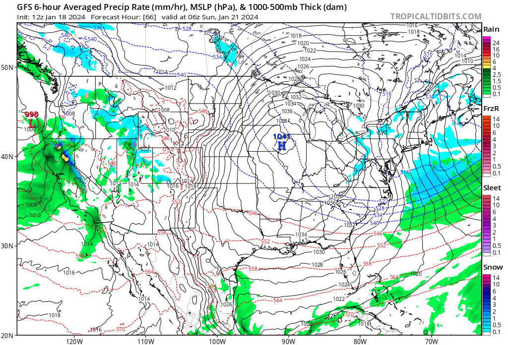
tropicaltidbits.com

Snow showers are expected today before the next system brings precipitation tomorrow. Temperatures range from about 30 degrees at base to 20 degrees at 10,000 ft. Conditions are generally expected to be cloudy before precipitation really kicks in tomorrow. The above graphic shows current conditions across the United States. The next system can be seen bringing rain to the Pacific Northwest.


Short term:


This system will start producing meaningful snowfall throughout the day on Thursday. About 10 inches of snow can be expected, which should make for good skiing conditions.  


Long term:


weather.utah.edu


High pressure looks to regain control over the area by Friday afternoon. That high will stick around for a while. Model runs show systems unable to push through the Pacific Northwest into our area, leading to quiet weather. Hopefully this forecast changes and the storms can share the love over here. The above graphic shows one of the systems, which is not forecast to produce meaningful precipitation here. 


Backcountry comments:


If you will be traveling in the backcountry make sure you have the proper equipment and know before you go. For the whole avalanche forecast and all things avalanche head over to our friends at the Utah Avalanche Center.


Sunday, January 21, 2024

Warm Air, Moist Air, Snow Here and There

TL;DR:

    Light flurries will continue throughout the day with warmer temps and light winds. Much of the same is to come this week. Keep your low light lenses in and forget lots of layers, no need in the warmer temps.

Nowcast:

    As a light snow falls this morning, the sky is cloudy and the air warm. Temperatures are just below freezing around mountain bases and dipping to the low twenties around mountain tops. Expect continued light flurries throughout the day with warmer mountain temps.  


Alta


Short-Term:

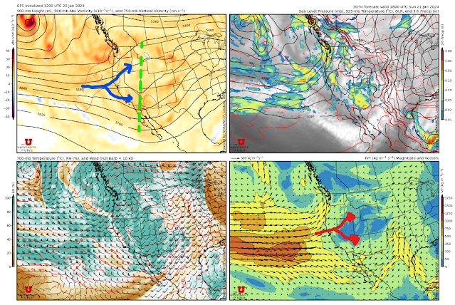
    Today, an embedded shortwave trough will move over Utah, bringing with it some moisture and lots of warm moist air. While we can expect some precipitation today, don't get your hopes up as this precipitation is enabled by the moist air and the help of orographically induced precip.

As highlighted below in the upper left panel you can see the embedded trough situate itself over Utah. One feature to note is how the flow splits. The split flow is highlighted in both the upper left panel and the bottom right panel. You can see how the moist air has split around Utah. As a result of the split flow Northern and Southern Utah may see more promising totals than the cottonwood canyons. 

In the cottonwood canyons small snow totals are expected topping out at an inch or two. Models show the freezing level remaining elevated as the warm air is advected to the area. The warm air we are receiving is a double-edged sword, with it we are seeing higher temperatures but it's providing the moisture needed for any precipitation. 


U of U Atmospheric Science

Long-Term:

    Looking through the next week, the current weather pattern we are experiencing will continue. The embedded trough that will be set up over Utah today will park itself yet will continue to dig South. As a result, the moisture will continue to miss us. Small flurries like we're experiencing today will happen throughout the week, but large snow totals shouldn't be expected.  

Backcountry Comments:

The backcountry remains a place to hold extra caution; avalanche conditions are considerable on low, mid, and upper elevation slopes from the west side of the compass to the Southeast side. One thing to keep in mind when traveling in the backcountry is the difficulty of making avalanche decisions in conditions such as the ones we are experiencing.  The choice is not clear as it is with low and extreme danger; during periods of considerable danger, the most avalanche fatalities have occurred. 

Snowbrains.com

If you plan to travel in the backcountry, make sure you are properly equipped and know before you go. For a full avalanche forecast, observations, and all things avalanche head over to our friends over at the Utah Avalanche Center.


If you are a snow nerd like many of us, you may find this new research that could change the way snowmaking is performed. Find it here

Saturday, January 20, 2024

Refills on the way

TL;DR: A shortwave trough will affect Northern Utah tonight into tomorrow morning bringing moderate snowfall to upper elevations and rain to the valley. The main trough axis will pass tomorrow night, favoring southern Utah mountains.

Nowcast: It is currently 36 F at the base of Alta with moderate wind from the SSW and partly cloudy skies. Expect the temperature to decrease throughout the day as a shortwave trough approaches the region, bringing overnight snowfall. 

Short-Term: A trough currently sits along the coast of Northern California driving SW flow into Northern Utah. A shortwave will be ejected from the main trough axis and affect Northern Utah tonight around 5 pm. This should be a mild storm bringing 6-12” to Alta through Sunday midday.

(University of Utah: https://weather.utah.edu/. The main take away today is the warm moist air being advected into the region shown by green in the plot above. Notice the Blue 0 C line extend all the way above 750mb, which loosely represents the snow level.)

Long-Term: Sunday night the main trough axis will become more unorganized as it propagates eastward. The best dynamics will be to our south affecting Southern Utah and Arizona. The Northern Utah mountains may see chances of snow at times but no large accumulations are expected. After Sunday mild ridging will occur until Tuesday/Wednesday, when we see another chance for snowfall.

Backcountry Comments: If you are headed into the backcountry, visit UAC for the latest information. 


Friday, January 19, 2024

A classic Sierra steal

TL;DR:

The storm earlier this week has passed. Over the next few days, we'll see decreasing temperatures and some snowfall later this weekend. Due to our active January, most sites are observing SWE above median amounts. 

Nowcast:

Currently, conditions hover around 37 degrees at the base and 29 degrees at the summit. Winds are light and out of the WNW. Cloud cover is mostly cloudy with brief periods of sunshine. Currently, a trough sits off the west coast of the US.

Courtesy: Alta Ski Area

Short-term:

A strong low-pressure trough will make landfall in northern California today. Below is the current upper-level water vapor channel from the GOES satellite. You can see the trough labeled in yellow. 

Throughout the day today and into tonight, cloud cover should increase. I don't expect any snow to start falling until later in the day on Saturday. However, expected snow totals are limited due to the path of the storm tracking over the northern Sierra Mountains and the trough not making it very far inland before breaking up and turning to the north. 

The SREF & NAEFS ensembles vary on this storm, but no members suggest more than 10-15 inches throughout the weekend in upper Little Cottonwood. These values seem high and come in at a 5-7-inch storm total for the weekend. The periods of most intense snowfall will be Saturday evening and Sunday evening, with snow tapering off during the day. Here's the LCC guidance:

Courtesy: UofU ATMOS

Long-term:

The GFS and the ECMWF have the faucet essentially turning off here in the later half of the model run. Some scraps might sneak through to Utah, but both models have two large troughs tracking north into British Colombia. Large-scale blocking or ridging isn't taking place. If you're a frequent USW reader, you know this is quite far out and subject to change.

That's all I've got for today. As always, if you plan on recreating in the backcountry, please check out the avalanche forecast from our friends at the UAC.  


Thursday, January 18, 2024

Major snow storms over, so go skiing!

 TL;DR:

The vast majority of the snow has already fallen, future forecasted storms will bring small amounts of snow. Couple inches over the weekend.

Nowcast:


Map of avalanche risks https://utahavalanchecenter.org/


After the past days of intense snowfall, especially with yesterday's dumping, we finally get to some calm weather today. Currently 39 degrees at the SLC airport with no wind at all. Expect these conditions to last throughout the day with clear skies, perfect weather to get out into the mountains! Although, be careful with any backcountry skiing, as avalanche risk is high today in the Wasatch back due to the recent snowfall.


Short term:

https://www.tropicaltidbits.com/analysis/models/?model=gfs


Over the next couple days, expect warm and dry conditions as a ridge builds over Utah. Towards Saturday night and early Sunday morning, we should get another trough bringing some isolated snow showers to Utah. I'm not sure exactly how much snow we'll get, but it most likely won't be near the previous amounts of snow we've gotten lately.

Long term:


After the trough comes through on Saturday/Sunday, we'll continue getting isolated snow showers throughout Wednesday. Other troughs follow this weekend trough, but nothing major. Eventually, leading into Thursday/Friday, a ridge will build over Utah giving us warmer temperatures and higher pressure. Unfortunately, the GFS, the forecast model, shows high pressure over Utah for the remainder of January, Hopefully, this will change, so inversions don't build up and we get more snow. 

Backcountry comments:


If you will be traveling in the backcountry make sure you have the proper equipment and know before you go. For the whole avalanche forecast and all things avalanche head over to our friends at the Utah Avalanche Center.


Wednesday, January 17, 2024

It Is Dumping

 TL;DR Atmospheric river continues to bring lots of moisture from the PNW maintaining a very active pattern. Heavy snow all today into Thursday should be a nice addition to the 114 inches provided from the last ten days of snow.

Heavy precip seen from snowbird

Looking at the snow interval further shows heavy precip rates from Alta Collins data


Nowcast: With overcast skies this morning snow has returned to the mountains. Temperatures in the  upper teens to 20s this morning but expected to warm through the day due to warm air advection from the 20-30 mph winds from the west-southwest. As a shortwave trough comes from Oregon moving eastward it will bring some vorticity max's over southern Idaho and northern Nevada. Pre trough precipitation started to occur over the forecast area brining from trace amounts to an inch depending on where in the valley you are located with totals looking they were about 3 inches at Alta so far. As there is a short lull in the precipitation around 9 am the storms are only expected to get more intense being coupled with isentropic ascent. That is looking like potentially another couple inches of snow in the valley unless temperatures warm too much making potential for freezing rain or just rain, as well as what I think will be about 12-15 inches in the mountains today with more on the way over night.

Some warming predicted could turn the snow in the valley to rain.

Short Term: Some more vort max's expected to move through the area starting around 8pm tonight and lasting into early tomorrow morning as the winds shift back west-northwest. Hopefully bringing another 5-10 inches overnight to the upper cottonwoods. After that the precipitation should cease for a while with slightly warmer and drier conditions move in along with the strong building ridge forecasted to be directly over us Friday night to Saturday morning.

NAEFS

SREF Pretty decent agreement with both forecasting between 10 and 20 inches for today


Long Term: With ridge moving out Saturday evening it should be a nice day to get after it. A series of short waves is on the way behind probably to affect us later Saturday night into the next week. These short waves are following a bit of a different pattern than we have been seeing from the previous storm cycles though. These are seeming to come from central California tracking from the southwest to the northeast to get over us and having some split flow starting over central Nevada come Sunday. This different track seems to be favoring southern Utah/Arizona more than the previous storms not meaning dry conditions for up north but just meaning that there will be much more uncertainty forecasting for central and Northern Utah.

Todays forecast with storm coming from the northwest, see the isobars slant down towards SLC

Compared to the beginning on next weeks storm where isobars slant up from the southwest towards SLC 


Backcountry Comments: Persistent dangerous avalanche conditions continue with a considerable danger and with heavy snowfall rates expected to hit 2 inches per hour at times it is a good day to lay low in the backcountry. What to do? Stick to slopes less than 30 degrees today and avoid anything conected to steeper terrain. Check out the full avalanche report at Utah Avalanche Center

Tuesday, January 16, 2024

The Snow Continues

TL;DR:

Calm conditions today will change to mountain snow and valley snow and rain overnight as our next storm moves in. Potential for more snow over the weekend.


Nowcast:


We are currently situated under a shortwave ridge that is responsible for the calm conditions we are experiencing today. Cold temperatures persist from our pervious storm system. You can expect a high near freezing for today with calm winds around 5 mph. Although it is cold, it could always be worse. The Midwest and Great Plains are experiencing extremely cold weather with temperatures near or below 0 F and wind chill values well below.

Temperatures across the US as of 11 am MST (18 UTC)

The shortwave ridge will persist throughout the day but will begin to weaken as the next trough moves into the region overnight through early morning Wednesday. A chance of precipitation is possible with the passage of this trough.

The 4-panel plot from weather.utah.edu showing 500mb heights, precipitation, temperature, and IVT for the upcoming trough passage 


Short term:


Precipitation is expected with this trough, but there is uncertainty in precipitation type. Snow is expected in the valley Wednesday morning transitioning to rain by the afternoon as temperatures begin to increase. Southerly flow will be the culprit of the snow to rain transition in the Salt Lake Valley. Snow totals are dependent on when and if the winds shift to southerly. Valley snow totals range from no accumulation to 2 inches.


A winter weather advisory exists for the North and Central Utah mountains. Expected snowfall for the Cottonwoods is around 15 inches, with the low end being around 9 inches and the high end around 17 inches. Mountain snow is expected to persist through Thursday morning.

National Weather Service forecasted snowfall totals

Long term:


Mountain snow will taper off Thursday as another ridge will build over the Western US. Models show multiple lows dancing over the Pacific with a shortwave trough branching off from one of these lows and moving over the Western US this weekend. This shortwave trough has the potential to impact Utah on Saturday. 


Scattered precipitation will persist over the Western US through early next week, but will miss the Northern Utah mountains.  The next chance for precipitation in Utah is late next week as a there is potential for a digging trough to impact our region. Check back with the forecast next week to see how these storms evolve. 


Backcountry comments:


Dangerous avalanche conditions persist, and backcountry travel is not recommended. The existing avalanche hazards are a persistent weak layer and wind drifted snow on most faces and elevations of the mountain. Everyone should stay off and out from under slopes steeper than 30 degrees. Check the full forecast at UAC.


UAC Avalanche forecast for Salt Lake Mountains


Courtesy

Ashley Evans