TL;DR:
The nice weather we've been having over the past few days will break tonight as another storm makes its way into the state. This storm will be smaller than earlier this week, but substantial accumulation is likely in the mountains. The NWS has issued a winter storm warning starting this afternoon and continuing through Sunday evening.
Nowcast:
We have high clouds over the state currently.

Mountain temperatures sit above freezing at the base and below freezing at ridgeline. I expect temperatures to cool off throughout the day.
Short-term:
A storm will impact the region starting this afternoon/evening and continue through Sunday evening. SREF ensembles show snow accumulation beginning around 6pm MST. The period of highest accumulation will be tomorrow morning around 3am MST. The HRRR shows snow showers stopping around 8pm MST on Sunday.
As far as accumulation goes, the HRRR LCC guidance shows 20 inches for this storm, and the GFS guidance shows 13 inches. The main difference between the two models is that the GFS has the Wasatch only receiving 1 inch of water, while the HRRR shows 1.75 inches.
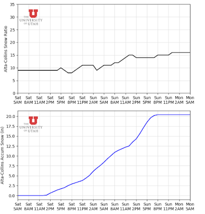

Given all of this, my accumulation estimate would be a 75% chance of total accumulation >15 inches with a 25% of accumulation of 20 inches at high elevations.
Long-term:
After the storm this weekend, 2 more storms will impact the state, but they don't look all that promising in the Wasatch. The first storm will come in late next week, but the highest accumulation will be in southern Utah. The second will pass through next weekend and could provide some accumulation in the Wasatch; we'll have more for you next week.
From a pattern viewpoint, a ridge builds off the West coast after the 2nd storm mentioned above. Right now, it doesn't look too strong, but time will tell. There could be a break to the active pattern we've been in for the past 5 weeks.
No comments:
Post a Comment