Thursday, March 28, 2024

March Delivers

Tl;Dr: More snow today, a break on Friday, more snow Saturday and Sunday. 


Nowcast: 


Winds blow from the south atop Little Cottonwood Canyon at a modest speed of 25 mph with gusts at 40. Those winds will continue throughout the morning, ushering in our next storm that will deliver 3-7" of new snow by the time chair lifts stop spinning today. Not bad, considering all of the snow the Wasatch has received this past week (see Michael's post from Tuesday). Temperatures sit in the high teens to low twenties, and winter is far from over. 

As of Tuesday, March 26, Alta officially passed their 43-year average snowfall when it hit 545" for the season. Yahoo! 

Short-Term:


Snow should start falling later this morning, with a big initial push right around 0900 - 1000 local. This front should linger throughout the rest of the day before tapering by tonight with snow in the forecast for tomorrow, Friday March 29. 

Here's what 1600 local looks like on the HRRR - you can see .25 inches of water by the end of the (resort) ski day, and with snow to liquid ratios of right around 18, that should amount to at least 5" of snow.  


HRRR initialized 1000 UTC per ATMOS Weather 

Things look to be dry tomorrow with perhaps some in and out flurries before the next wave of snow starts to knock on the door as early as Friday evening. 

https://weather.utah.edu/

Long-Term:


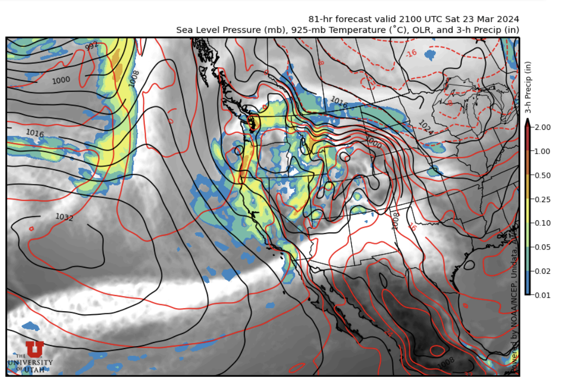
As stated, we have another storm rolling in to the Wasatch Saturday and Sunday. Looks like there might be another hit of moisture on Monday, too. 


More data per Professor Powder 

Spring in the Wasatch is the absolute greatest! 

Backcountry Comments: 


Yesterday's avalanche danger was mostly moderate, but please remember spring conditions change fast. Especially with all of the new snow we have gotten, there are still several reports of soft slab / new snow avalanches across the Wasatch. 

For all things backcountry, go over to the Utah Avalanche Center to get the latest safety and travel advisory. 


Tuesday, March 26, 2024

Soft on soft

TL;DR: Resorts are reporting more new snow today on top of the snow that fell over the weekend. Expect additional snow showers before a break on Wednesday into Thursday.

Nowcast: Under a west-northwest flow, mountain temperatures are in the teens to twenties, and it is snowing in the central Wasatch. Resorts are reporting between 1 and 6 inches of new snow on top of the snow that fell over the weekend, bringing storm totals to 1.5 to 2.5 FEET of snow. Skiing and riding is excellent in the Wasatch right now.

Source: Alta Ski Area

Short-Term Forecast:

On-and-off snow showers will continue today in a west-northwest flow, before tapering off as Wednesday approaches. The 6 UTC HRRR model calls for an additional 0.29 inches of precipitation for Alta by Wednesday morning (more further north near Ben Lomond Peak). 

Source: University of Utah Department of Atmospheric Science

With snow-to-liquid ratios around 15, we could se close to 5 more inches of snow today before things clear out and we see a brief period of ridging for tomorrow (see upper left panel below):

Source: University of Utah Department of Atmospheric Science

Mid-Long Range Forecast:

Snow begins in the central Wasatch again by late Thursday, continuing through the weekend with potentially significant accumulations. This storm does appear to be warmer, with mid-mountain temperatures close to 30 °F. However, it has substantial liquid, with the GFS model forecasting an additional 2.5 inches of precipitation and 30 inches of snow on top of the snow that will fall today.

Source: University of Utah Department of Atmospheric Science

Enjoy the excellent March powder!

Saturday, March 23, 2024

Winter is BACK

  TL;DR:

Winter is far from over and it makes a triumphant return starting this afternoon; this week won't feature one single massive storm, but rather a slow and steady accumulation of snow.

 Nowcast:

It's windy and overcast in the mountains right now; at Snowbird's Hidden Peak, we've got sustained winds of around 25mph and gusts up to 45mph, with weaker winds at less exposed locations. Temperatures are fairly warm (25-30°F), but the windchill is dropping the feel-like values, so make sure you dress appropriately...

 Short-term:

Winter is not over yet, and it will make its return this afternoon with mountain snow starting around 3-4pm; it will snow solidly and consistently overnight before we transition into more showery snow tomorrow. I'm not expecting a whole lot out of this first wave... but I also tend to keep my expectations way too low :) At any rate, I'm forecasting around 6" for most mountains by tomorrow morning, with the potential for more in LCC.

In terms of snow quality, temps will crash tonight behind the cold front and bottom out in the mid-20s or so in the mountains; thus, I wouldn't expect blower pow tomorrow, but it should be fairly nice!

The Canadian model is quite enthused about another strong burst of snow overnight Sunday into Monday, but other models aren't as into it, so we'll see how that works out...

 Long-term:

The next seven days look promising for those of who who were craving a return to winter. Check out the model plumes for Canyons (top) and Alta (bottom):


You can see that the lines just keep going up, indicating slow and steady accumulation this week.

Enjoy the new snow! This may be true winter's grand finale before we transition into spring skiing...

If you choose to venture into the backcountry, make sure you have the proper training and equipment and know before you go. For the avalanche forecast and other avy-related resources, visit utahavalanchecenter.org.

Wednesday, March 20, 2024

Changes on the Horizon

  TL;DR:

Short term quiet but there are big changes on the horizon


Nowcast:


tropicaltidbits.com

It is currently sunny, with no precipitation expected as a high pressure system continues to influence our weather. 


Short term:


In the next few days, the high pressure should continue to cause dry conditions. The next cold front should start to cause precipitation in the area by Saturday night. 


Long term:


weather.utah.edu


This trough should cause some precipitation over the weekend and should lead to substantial accumulation over a few days. It is too early to provide exact estimates so keep checking this blog to get to most up to date information!


Backcountry comments:


If you will be traveling in the backcountry make sure you have the proper equipment and know before you go. For the whole avalanche forecast and all things avalanche head over to our friends at the Utah Avalanche Center.


Monday, March 18, 2024

A Break from the Snow

 TL;DR:

Warm temperatures over the next week, nothing exciting. Possible showers by next weekend. Highs in the lower 60s, lows in the upper 30s and lower 40s. 

Nowcast:


Clear day today, with no clouds in sight. The temperature is hovering around 60-64 degrees. After our crazy wind storm the past weekend, it's not too windy today which is a nice break.


Short term:


Over the next couple days, expect temperatures to stay in the 60s for the high and the 40s for the low. An area of high pressure is currently situated over the Wasatch Valley, which means sunny days. With the spring equinox coming soon, we've already reached spring weather. This week is a perfect week to study outside.


Long term:

The current weather pattern will stick around until the weekend, when a cold front associated with a low pressure trough is expected to move through the area. This cold front will bring rain or snow to the valley, it's too early to make estimates on where it'll snow or rain. Next week should be colder than this week, so hopefully we will get some snow. 

Backcountry comments:


If you will be traveling in the backcountry make sure you have the proper equipment and know before you go. For the whole avalanche forecast and all things avalanche head over to our friends at the Utah Avalanche Center.


Friday, March 15, 2024

Mostly sunny, mostly windy

Tl;Dr: Winds will continue blowing from the east around 20 mph throughout the day today before slowly decreasing to single digit mph and from the west tomorrow. 


Nowcast:


There was much talk yesterday about the unorthodox easterly winds the Wasatch was set to encounter. As Nikki Champion from the UAC said in her backcountry forecast; "unusual weather patterns come unusual loading patterns." 

Here is what the anemometers atop Mt. Baldy show over the past 24 hours: 

24 hour data collected from MesoWest: Mt. Baldy (AMB) station

It looks as if winds didn't really start to pick up until midnight or so, blowing steady around 30 mph, gusting into the mid-to-high 40's, and continued to come from the SSE. 

As for today, expect the winds to stay right around 20 mph, with no change in direction. Temperatures at the height of the Cottonwoods will range from 25-30 degrees F, with clouds departing by the start of the afternoon. 

Short-Term:


Winds will continue from the east all the way through lunch time tomorrow Saturday March 16, before a slight transition to N, and then back to east. Aside from the continued a-typical direction of these winds, they do look to come to a halt by Sunday. 

Here's what we can expect tomorrow afternoon (see bottom left for wind direction and speeds): 


And then again on Sunday morning: 


As the GFS shows, we can expect winds to slow down, mostly clear skies, and unfortunately, not a ton of snow. Don't be surprised if temperatures hit 40 degrees F tomorrow in the late morning / early afternoon! 

Long-Term:


Long term models suggest a return to winter by the end of next week, but it's too far out for me to really comment. Check back in with your friends at Utah Ski Weather as next week progresses! 

Backcountry Comments: 


Backcountry travels remains complex, with the easterly winds causing slabs in places we might not typically expect. This, combined with the heavy snowfall we received on Tuesday and Wednesday, call for careful route finding and strong decision making. 

For those starting to plan their spring missions to other nearby ranges, check out the forecast for Moab/Abajos, where the Abajos are projected to receive 18-24" by Saturday morning! (Forecaster Dave Garcia also goes on to say this storm is unpredictable and is anyone's guess though...) 

If you plan to travel in the backcountry, head over to the Utah Avalanche Center for all things avalanche safety, planning, and guidance. 

Thursday, March 14, 2024

Easterly Winds for Pi Day

TL;DR: Yesterday was an excellent blower powder day in the Wasatch. We clear out today and into the weekend with strong easterly winds to end the week and a return to high pressure.

Nowcast: Storm totals in the central Wasatch range from 9 to 22 inches over the past 24 hours. This was a right-side-up storm that made for excellent skiing and riding conditions yesterday. As the low pressure center tracks to our south, strong downslope easterly winds will pick up.

Short-Term Forecast:

For today and into tomorrow, the low pressure center that brought us some mid-week snow this week will track to the south near the southern California-Arizona border bringing strong easterly winds as shown in the GFS forecast below valid later today. This is an atypical flow direction for the Wasatch.

Source: University of Utah Department of Atmospheric Science

We'll see a mix of sun and clouds and maybe a snow shower or two, with temperatures in the mid to upper 20s at resort level.

Mid-Long Range Forecast: 

As we progress into the weekend and next week, a ridge of high pressure builds in the region, bringing a period of warming temperatures and spring-like weather. There are a hints of a return to snow for the following weekend. 

Enjoy the new snow!