Saturday, March 25, 2023

SURVIVED? SNOW AND COLD

TL;DR: SURVIVED YESTERDAY? LIGHT SNOW ALL WEEKEND, COLD TEMPS CONTINUE

Nowcast:

Current conditions 9am MTN 2023-03-25 via https://www.wrh.noaa.gov/map/

Looks like a cold front came through and temps are below freezing in the city and down to single digits above 9,000 ft in the Canyons. Right now, winds are mostly from the west at 5 mph gusting to 11. 

Surface weather map shows high pressure parked east of Utah as it exits the state. Mountain-snow showers to weaken during the day as the system heads eastward. 

Surface Weather Chart via https://www.weather.gov/zid/surface

Short term: 

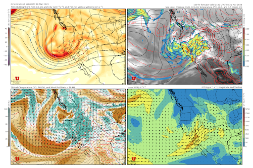
The GFS shows continued west/northwest flow as a low closes over southern Idaho. Looking at the 500 mb upper air chart to see steering flows: 

60 hr forecast from the GFS via https://www.pivotalweather.com/

Cold temperatures will continue and wring out some light snow showers through the day Saturday and Sunday through Monday morning. A couple of inches expected each day to continue building our record snowpack: 

Point-model output from the GFS for a spot in the Wasatch Mountains. Cold temps persist with cloudy conditions and light snow through Monday afternoon. A shift in conditions for Wednesday will bring more moderate temps and another pulse of snow. Via www.spotwx.com

Long term:

Jumping ahead to Wednesday - a low comes onshore around Northern California and this changes the flow pattern to come from the southwest. Warming temps could be a relief for those looking to thaw out and a mid-week snow-treat for the skiing and snowboarding crowds. 

Wind barbs showing a shift to SW flow over Utah starting Wednesday. With it, warmer temps and precipitation. 

Backcountry comments: 

LOTS of wind overnight and LOTS of snow caused havoc in the Canyons and the resorts yesterday. Big impact to the snowpack and expect increased hazard with the rapid change. 

If you will be traveling in the backcountry make sure you have the proper equipment and know before you go. For the whole avalanche forecast and all things avalanche head over to our friends at the Utah Avalanche Center here: Utah Avalanche Center

Monday, March 20, 2023

Here. We. Go.

TL;DR:

    With favorable conditions shaping up, buckle down for lots of snow through the first half of this week. HERE, WE, GO!

Nowcast:

    With only 7" so far from this storm we are off to a slower-than-expected week, that being said, fear not there is more snow on the way. It has been snowing throughout the day today in the cottonwood canyons with temperatures in the low twenties, dipping to the upper teens around the mountain tops. Winds are blowing out of the West around 20-30 mph, keep an eye out for blowing snow as the storm rages on. The snow will continue through tonight until around midnight when the storm will settle.

Through today and into this evening a trough is digging off the west coast. As a result of the orientation of the trough, the westerly upper-level flow will prevail. Accompanying that flow is a strong band of moisture that lies slightly south of Utah. 

Short Term:

    Tuesday will bring a slight break in the storm with moisture being the limiting factor. Northern Utah may see some scattered showers but nothing significant. Down in Southern Utah however, some snow may fall with the injection of moisture as well as some strong vorticity advection creating an optimal environment for snow.  

    Yet, you Northern Utah dwellers get ready as the storm will start back up Tuesday afternoon and evening as the moisture surge will reach into the Northern stretches of the state. Snow totals range up to an additional 5-8" by midnight before the storm really starts to kick. 


    The maps above are valid at 1500 UTC Tuesday (11:00 am). This is just prior to when the storm will kick back into action. In the bottom right and bottom left the moist and dry areas are highlighted. Note that southern Utah will be significantly moister, this will be favorable for the La Sal Mountains along with those Southern ski areas. In the top right map take note of the significant area of strong upper-level vorticity and the location of Utah relative to the trough. Note that as a result of this orientation significant vorticity advection will be brought to Utah, accompanying the cool temperatures will make for excellent upper-level dynamics to be in place for Wednesday. 

Long Term:

    Looking to Wednesday the upper-level flow will shift to a more Southwesterly flow helping to bring more significant moisture levels helping to classify this as a low-level atmospheric river event (AR 1/2 along the Wasatch front). The moisture accompanying the cool temperatures and favorable upper-level dynamics will result in some significant snow totals. Areas of the Wasatch Front could receive nearly 2 feet of snow with isolated areas in the upper alpine receiving nearly 2.5-3 feet. In Southern Utah similar totals are possible by the end of the storm.

U of U Atmospheric science

If you plan to travel in the backcountry know before you go and have the proper equipment. Avalanche conditions will be heightened this week with the addition of lots of snow and a prolonged period of wind that will have the ability to blow snow. Consult our friends over at the Utah Avalanche Center for the full avalanche forecast and observations.

Thursday, March 16, 2023

Bluebird powder day, with more on the way

 TL;DR: Bluebird says for the weekend with another storm moving through next week. 


Nowcast:

It is a spectacular bluebird day today. With around a foot of new snow and colder temperatures, the snow quality should be great today. It is colder than it was yesterday with highs in the teens and low 20s. There wont be a cloud in the sky today. If you are planning on going out remember to ring some sunscreen.

                                                                High Rustler, Alta


Short Term:

It should remain clear through the weekend with temps slowly rising but still only reaching the mid 20s. There could be accouple low level clouds that settle into the canyons, but there will be no precipitation associated with them. The snow that fell yesterday should stick around through this weekend, but there might be a bit of crust that forms due to solar radiation and low temperatures.


Long Term:

    It looks like there is another system that will role through early next week. There is a large low pressure system that will be moving across the wester US starting Monday. It looks like the brunt of the storm will hit midday Tuesday and carry through into Wednesday. Curranty, the NAEFS is predicting around 30 in from Monday to Wednesday, but it might be a little optimistic due to the uncertainty of the models. 


Tuesday, March 14, 2023

POW. WEDNESDAY.

Nowcast:

09:42 MTN / 15:42 UTC Camera Display looking EAST from the Neil Armstrong Academy in West Valley. Via https://home.chpc.utah.edu/~u0790486/wxinfo/cgi-bin/uunet_camera_explorer.cgi?cam=NAA

Current Temperatures and Wind Direction around I80 and the Cottonwoods. Via https://mesowest.utah.edu/cgi-bin/droman/mesomap.cgi?state=UT&rawsflag=3

Overcast skies with cloud layers at 5500 ft, 12000 ft, and 14000 ft according to the KSLC METAR (KSLC METAR) for 1454z. Winds are from the south at 16 mph at the airport, consistent with ridge top winds at Hidden Peak blowing 25 mph with gusts to 40 mph. 

Temperature is in the low 50s in the valley and just below freezing (low 30) up at the ski hills. 

Satellite / Infrared imagery shows a 'big red lobster' i.e. the remnants of an atmospheric river heading our way from the southwest. This atmospheric river brings moisture, and unfortunately warmth, to the region. 

Infrared imagery with the incoming atmospheric river as an 'angry lobster'. Via https://weather.cod.edu/satrad/?parms=regional-southwest-14-24-1-100-1&checked=map&colorbar=undefined

Short term: 

Snow is expected to start late this afternoon bringing 3" before midnight and another 15" by sunrise tomorrow. Winds are expected to be ripping during this event with consistent gusts exceeding 40 mph. 

Snow continues throughout Wednesday with another 12"(ish) to fall during the day. 

Freezing levels should remain above 7000 ft until a cold front barges through Thursday morning. 

Ensemble plumes showing the bulk of the precip to happen overnight Tuesday and throughout Wednesday. 

This incoming storm has prompted a Winter Storm Warning from NWS/NOAA with 'Significant Mountain Snow Accumulations'. 
Sounds like a POW day to me! 

Tuesday afternoon through Wednesday Morning - expect mountain snow courtesy NWS/NOAA https://www.weather.gov/slc/ 


Long term:

The cold front will turn off the tap until shortwave troughs move through this weekend, potentially bringing precipitation on Saturday or Sunday. 

Backcountry comments: 

Winds and loading contribute significantly to snowpack instability. Changing temps as they increase or drop with the cold front will increase the likelihood of natural and human triggered avalanches. Be mindful of the intense winds and dense upper snow layers as they can be a bed surface for the new storm snow to slide on.  

If you will be traveling in the backcountry make sure you have the proper equipment and know before you go. For the whole avalanche forecast and all things avalanche head over to our friends at the Utah Avalanche Center here: Utah Avalanche Center

Monday, March 13, 2023

Spring who?

TL;DR: We will have a quiet start to the week as we wait for a shortwave system with favorable upper-level dynamics and moisture transport to hit Wednesday morning. 


NOWCAST: Alta has gotten 4" in the past 24 hours and is currently 21 F at the base with light WNW winds. High pressure currently dominates the region.

(Alta Ski Weather: https://www.alta.com/weather) 

Short-Term Forecast: Wednesday morning a shortwave trough will barrel through the region coupled with good IVP from an atmospheric river penetrating through California. Winds at the 700mb level (~11,000 ft) will be positioned from the SW during the arrival of this storm. Storm snowfall totals range from 30"-50" at Alta. 
(University of Utah NAEFS, https://weather.utah.edu/) 

Long-Term Forecast: After the trough passage on Wednesday, slightly high pressure will build into the region for the rest of the week. Smaller feature shortwaves are possible throughout the rest of the week but none will bring considerable snowfall. Our weather pattern seems to stay very progressive and this next ridge will be quickly pushed out by a deeper trough early next week. 
(500mb Geopotential Height Anomaly, Tropical Tidbits: https://www.tropicaltidbits.com/)


Sunday, March 12, 2023

Snow today; Bigger storm mid-week

TL;DR: Light snow showers today will bring a light refresh to the mountains. A bigger storm with lots of moisture will impact the region starting Tuesday afternoon and lasting through Wednesday.

Nowcast: After the sun briefly made an appearance yesterday, snow has returned to the Wasatch today. Most resorts are not reporting any new snow for the past 24 hours, aside from 2" at the BCC resorts, and 1" at Deer Valley. Light showers are falling throughout the region now, and visibility appears to be a challenge per Alta Ski Area's Superior webcam.

Source: Alta Ski Area

Short-term Forecast: Today's storm is not an exceptional one, but it should provide a few inches of fairly low-density snowfall in the Wasatch. By this afternoon, the University of Utah's GFS-derived forecast for Alta calls for 5" of new snow - a nice Colorado powder day :).

Source: University of Utah Department of Atmospheric Science

Fortunately, winds are not too strong today, with peak gusts around 30 mph from the west at the highest elevations.

Mid-Long Range Forecast: A bigger storm is on tap for mid-week, but it won't contain light, dry powder. Just like our system on Friday, this storm is associated with an inland penetrating atmospheric river with southwesterly flow. This can be seen clearly in the 0600 UTC valid for early Wednesday morning.

Source: University of Utah Department of Atmospheric Science

In the bottom right panel of the above four-panel plot, we can notice the yellow and orange colors penetrating the interior western United States, signifying high moisture transport into the interior from the Pacific. Unfortunately, this is once again a pretty warm system, with 700 mbar (crest-level) temperatures at right around -2 °C (red dashed contour in bottom left panel). This would mean that we could see rain at resort-base level. Expect fairly high precipitation rates in the 0.25-0.5 in. in 3 hr range (upper right panel). With snow-to-liquid ratios around 7 to 1, though, this won't translate to the most impressive snowfall rates. The GFS calls for just over 1.5 inches of liquid precipitation equivalent for the upper Cottonwoods, which would translate to about a foot of heavy snow.

By late Wednesday, we clear out into next weekend.

Snowfall Forecast:

For today expect 1-4" at the resorts with maybe more if one does particularly well.

For the warm mid-week storm, we'll be looking at 10-20" of new snow for the mountains.


Saturday, March 11, 2023

Going, Going, And Not Quite Gone

TL;DR:

Enjoy the good weather for now, we've gotten lots of powder skiing and had to shovel more than we care for, be grateful for the sun. More snow may come in the middle of this week but there is still lots of uncertainty.

Nowcast:

Good morning folks and happy weekend, while this storm might have been slightly disappointing and didn't deliver as much as predicted, keep in mind beggars can't be choosers. Bringing only a 6" refresher this storm has also brought some clear blue skies for us to enjoy this weekend. Temperatures are cool today down around ten degrees at mountain bases and dipping into the single digits up around mountain tops. You may want to bundle up as strong west winds are whipping. Temperatures could climb slightly through the day but likely won't break above 30. This afternoon expect some high clouds to move into the area but today should remain relatively clear.

Alta

Short term:

Looking through the weekend not much snow is expected. Tomorrow we will see cloudy weather with some potential for some flurries here and there. Likewise, Monday we will see very similar weather with some potential for scatter flurries. 

Long term:

We can hold our hopes high for the middle of this week when we may see some of the higher snow totals that we had expected for this weekend. With an injection of moisture, there is potential for some snow dependent on how favorable the upper-level dynamics will set up for us. We may just have to wait and see given the wide spread that models are showing. 

Thursday, March 9, 2023

Pow train continues

TL;DR:

Lots of snow on the way, buckle down and get ready for some more powder skiing!

Nowcast

It is another beautiful day in the mountains with yet another light refresh to keep the skiing conditions excellent. Temperatures in the mountains are sitting in the mid-twenties around mountain bases and dipping down to as low as 10 degrees at mountain tops. Light westerly winds accompany the mild temperatures making for prime skiing conditions. 

Alta

Enjoy the skiing today but buckle up for the wild ride. Throughout today a large atmospheric river event is zeroing in on the west coast and will make landfall this evening. Astronomical water totals are predicted for the west coast and some impressive numbers for us here in Utah as well!

Short term:

As this large atmospheric river event begins to unfold, our neighbors to the west in California will see the first major impacts. Areas of the Sierra mountains could receive upwards of 7" of water, yet that may not all fall as snow given the large injection of warm air accompanying the moisture.  

Here in Utah, we will begin to see the impacts of the AR event in the early hours of Friday morning when snow will begin to fall. Through Friday the initial punch of the event will bring 10 - 12" of snow. Saturday we will see some snowfall bringing an additional 10 - 12"

Long term:

Following this weekend's event, we will have a short break to recover before another injection of moisture impacts the area. Wednesday we will see another significant event bringing an additional foot to maybe even two of snow. 

Friday, March 3, 2023

Keep on Keeping on

TL;DR: Today we will see a few inches fall throughout the day associated with a shortwave passing by the region. Beginning Saturday night, a more significant low-pressure trough will enter the region dropping anywhere between 1-2 feet of snow through Sunday. 

NOWCAST: A gloomy darkness is currently approaching the Wasatch front. It is 20 F at Alta and 18 F at Brighton with light winds from the WNW. 
(Alta: https://www.alta.com/weather)

Short-Term Forecast: Expect daytime highs to be in the mid-teens the next two days with lows in the upper single digits. Moderate ridgeline winds will switch from W to SW on Sunday. An approaching low-pressure trough will start snowfall Saturday night which will last through Sunday. Approximately 1-2 feet of snow will fall at Wasatch resorts. There is large variability between the ensemble of short-range models (SREF) and long-range models (NAEFS) for snowfall totals in this storm. So far this winter, SREF has consistently shown a dry bias for snowfall totals while NAEFS has slightly over forecasted but gotten closer to observed totals. Below shows how little these ensembles agree with each other on this storm. From how this winter has gone thus far, I would say snowfall totals will end up somewhere around the NAEFS mean or a bit lower. 

(SREF, https://weather.utah.edu/)

(NAEFS, https://weather.utah.edu/)


Long-Term Forecast: Saturday's low-pressure trough seems to be a stubborn one wanting to sit in the region until next week. This brings the potential of shortwave systems moving through the region with minor snowfall potential throughout the week. Models have already shown great variability between runs so we will need to wait and see how it plays out. 
(500mb geopotential height anomaly, Tropical Tidbits: https://www.tropicaltidbits.com/) 


Thursday, March 2, 2023

Sunshine today, Friday Dust, Sunday POW


 TL;DR:  Sunshine today, Friday Dust, Sunday POW

Nowcast:

Right now: Snowing. Surprised? 

Sprinter keener getting an early start at Solitude - top image from the parking lot and lower image from the top of powderhorn looking down to the village area. Courtesy https://www.solitudemountain.com/mountain-and-village/webcams


Temps are mid 20s as you start up the canyons and mid 10s as you get to the parking lot and trail heads. City winds are basically calm while ridges are blowing from the west-northwest 10mph gusting to 15. 

Temps (F) and wind barbs for the I80 to LCC Canyons courtesy https://mesowest.utah.edu/cgi-bin/droman/mesomap.cgi?state=UT&rawsflag=3

Short term: 

Light snow will taper off during the day and the sun could peak out for some afternoon rays. Winds likely to persist from the NW as a cold front makes its way into Utah this evening. 

Clearing skies from SE Idaho coming into northern Utah this morning. Low pressure system centered over southern Arizona spiraling counter-clockwise and continuing south-south east. Courtesy https://weather.cod.edu/satrad/?parms=regional-southwest-11-24-1-100-1&checked=map&colorbar=undefined


A large trough setup diagonally from Washington to Montana is coming at us and will bring the goods late this weekend. 

Enhanced IR showing a blob of green NW of Utah that's going to bring the next big POW drop. Courtesy https://weather.cod.edu/satrad/?parms=continental-conus-14-24-1-100-1&checked=map&colorbar=undefined

A couple of inches in the models for Friday with the main event kicking off late Saturday into Sunday, with 10-20" possible for the mountains. 

Forecasts plumes for Alta-Collins from North America Ensemble predictions courtesy https://weather.utah.edu/index.php?runcode=2023030200&t=naefs&d=PL&r=CLN

Long term:

Late next week is TBD, signs of a Friday storm are in the cards and stay tuned if that plays out. 

Backcountry comments: 

Winds have been more aggressive lately and there's some reactivity in the upper snowpack. 

If you will be traveling in the backcountry make sure you have the proper equipment and know before you go. For the whole avalanche forecast and all things avalanche head over to our friends at the Utah Avalanche Center here: Utah Avalanche Center

Wednesday, March 1, 2023

Happy Spring

TL;DR: Snow today will lead to a slight break on Thursday, before we see another wave on Friday and additional snow for the weekend. It's not stopping!

Nowcast: Today is the first day of meteorological spring, but it definitely does not look like it in the Wasatch. Flakes are flying in the mountains and valleys today, which should stack up to a few additional inches of snow, making for substantial snowfall totals this week.

Source: Alta Ski Area

Short-term Forecast:

Snow will taper off this evening before we see a ridge in place on Thursday. That won't last long though, as an additional wave will bring a light refresh on Friday. Expect another 5" inches from that wave, providing a nice refresh before the weekend.

Source: University of Utah Department of Atmospheric Science

Mid-Long Range Forecast:

The snow does not want to stop! My Saturday late day, heavy precipitation rates will once again filter into the region, bringing more substantial snowfall totals (see plot above). This is an exceptional winter, and looks to keep getting better.

Wrap-up:

Snow today will taper off. A light refresh on Friday and then dry on Saturday. Then a more substantial snow event for late Saturday into Sunday. We are just so lucky!