TL;DR: Is Southwest the best?
(Probably not, but it's happening)
I picked this desert theme image to suit, and see the atmospheric river of water vapor in the upper atmosphere:

Goes West, Low Level Water Vapor (Channel 10) via https://weather.cod.edu/. For more specifics about Chanel 10, see this great resource: www.star.nesdis.noaa.gov/goes/
Hawaii (bottom left) to Utah (top right).

Nowcast:
 |
| Current across Utah. See the red 'double dots' in southern Utah? They are 'continuous rain observed'. Similar observations throughout the region. No weather was observed at KSLC, but the light pink denotes a storm warning from the NWS. Image via https://aviationweather.gov/gfa/#obs. Radar reflectivity overlaid as well. Great Photo. |
 |
| Brighton (Great Western) at 1030am Feb6: https://brightonresort.com/conditions |
Short term:
Wetness incoming from the southwest to the Wasatch. Expect moisture to hit our door steps later this afternoon, with continued precipitation through Wednesday.
More south will likely equal "more better", but the high terrain throughout the State could help squeeze the moisture out, and more importantly, keep the freezing levels low.
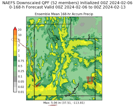 |
| Cropped NAEFS (North America Ensemble Forecast System) courtesy https://weather.utah.edu/index.php?runcode=2024020600&t=naefs&d=PP&r=UT showing MEAN precipitation (inches-water-equivalent) across the state for 168 hours (7 days). I think the 5" max is down south. |
Long term:
Changing pattern to hit the region Thursday, with temperatures dropping as the current system moves passed us:
10 Day forecast (single model run) via https://spotwx.com/

Backcountry comments:
Expect avalanche hazard to increase as new snow and precipitation collects on a sandwich of buried weak layers. Almost a Canadian setup, surface storm snow hazard is the immediate concern. Buried dragons persist below, capable of producing large avalanches if triggered from loading or the unfortunate 'sweet spot'.

If you will be traveling in the backcountry make sure you have the proper equipment and know before you go. For the whole avalanche forecast and all things avalanche head over to our friends at the Utah Avalanche Center here: Utah Avalanche Center
No comments:
Post a Comment