TL;DR:
Valley rain and mountain snow persist through tomorrow. A ridge will follow, bringing warm temperatures over the weekend. A chance for more snow and cold temperatures exists for early next week.
Nowcast:
Our current snowpack is doing better than average! Snowbird is sitting at 142% of the mean. And with continued snow, we can hope this number keeps going up.
 |
| SWE from the Snowbird SNOTEL site |
Temperatures in the valley are currently in the lower 40s. We can expect to warm to around 45 degrees this afternoon before dropping with our low in the mid 30s expected tonight. Our high temperature for the day was most likely reached last night right after midnight when we hit 47 degrees. Showers are expected throughout the day in the valley until 3am. After 3, a chance of snow is possible. The Wasatch are expected to continue getting snow through tomorrow.
Short term:
An upper level trough is the forcing mechanism that is currently bringing active weather to our region. This trough is associated with a cold front and PV anomaly that are driving our precipitation. This system is also associated with high precipitable water for our region this time of year, with values of PW = 0.42 inches as of 6am this morning.
 |
| Sounding data from SLC airport this morning at 12 UTC. |
As this trough progresses eastward, it will continue to produce mountain precipitation through tomorrow. I am expecting snow totals for the Cottonwoods to come in around 9.5 inches through tomorrow evening, with more of the snow occurring during the day today. Sustained winds around 16 mph are expected through today and tomorrow morning in the mountains. By Friday, a ridge will build into our region bringing back warmer temperatures for the weekend.
Long term:
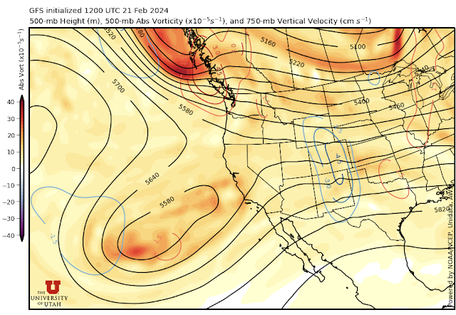
This ridge is accompanied by a stationary closed low positioned over the eastern Pacific off the coast of California. The ridge will continue to be positioned over Utah until early next week. The models are producing a deep trough with high PV values coming down from the Alaskan coast that will overtake the ridge. This trough has the potential to bring mountain precipitation and cold temperatures to Utah. Continue to check in over the week to see how this storm develops.
 |
| 500-mb heights valid for 15 UTC Feb 25th. The stationary closed low is seen over the Pacific with the deep trough and strong PV values progressing down the PNW coast. |
Backcountry comments:
Current avalanche danger is considerable above 8,000ft and moderate below. If you will be traveling in the backcountry make sure you have the proper equipment and know before you go. For the whole avalanche forecast and all things avalanche head over to our friends at the Utah Avalanche Center.
Courtesy
Ashley Evans
No comments:
Post a Comment