Wednesday, January 18, 2023


TL;DR:

Same-Same with some Dusting - Stretch the Legs

Nowcast:


Surface Analysis courtesy https://www.aviationweather.gov/progchart/sfc valid 1335 UTC (0635 AM MTN) - High pressure to the west and north of Utah at the moment influence our current break in the storm


Current Temperatures (F) courtesy of https://mesowest.utah.edu/cgi-bin/droman/mesomap.cgi?state=UT&rawsflag=3 mid 20s near University of Utah campus, mid teens around the ski hills of Big and Little Cottonwood Canyon 

Looking South from UofU campus - 0730 MTN today

Relatively calm conditions around the valley, light NW winds and broken clouds (5/8 to 7/8 of the cloud deck obscures clear sky, see the small clearing from photo above). 

The rest of today should look similar to this morning, add some sunlight and thinning clouds while temperatures increase slightly. Partly cloudy (or partly sunny? half full half empty kind of question) throughout the day. Potential for light snow showers as the surface air is pushed up and lifted over the Wasatch, marginal accumulations expected.

Short term:


The 60-hour forecast loop above shows promising conditions for single digit inches in the mountains on Thursday. Alta is calling for 2" as a low-pressure system tracks NW to SE from Idaho. 


Alta/OpenSnow Predictions for Thursday.. Wait till the Marketing department gets their hands on this. Courtesy https://www.alta.com/weather

Long term:

My attempts to track a trough that passes through Utah this weekend is shown in the GIF (hard-G, "GH-IF") below. The trough will likely lead to unsettled weather (intermittent precipitation, light snow accumulations) through the mountains and cloudy to overcast skies. There could be a punch of precipitation (1-2") for the mountains on Sunday. 

As the high pressure stays parked in the Pacific the intermittent and light snow could continue through early next week. 

Stretch the legs, maybe wax the skis, tighten your straps and bindings.. it's been a great couple of storms the last while.  

Upper level winds, forecast from GFS and Pivotal Weather https://www.pivotalweather.com/model.php?m=gfs&p=200wh_nb&rh=2023011800&fh=loop&r=na&dpdt=&mc=


Backcountry comments:

Some big storms have deposited some load onto the snowpack, the experts will be monitoring results and observations from the recent storms. 

If you will be traveling in the backcountry make sure you have the proper equipment and know before you go. For the whole avalanche forecast and all things avalanche head over to our friends at the Utah Avalanche Center here: Utah Avalanche Center


Tuesday, January 17, 2023

Don't Stop Won't Stop

TL:DR: A Trough will bring more snow today then shortwave ridging will build on Wednesday and quickly be replaced by another low-pressure system on Thursday giving the central Wasatch a dusting of snow. 

Nowcast: Temperatures currently range from 16 F at Brighton to 22 F at Park City. Windspeeds are calm and out of the SE. Snowfall will begin shortly. Here is what we received yesterday:

Past 24-Hour Snow Totals:

Alta: 11"

Snowbird: 17"

Brighton: 17"

Solitude: 12"

Deer Valley: 7"

Park City: 9"

(Mt Superior, Alta 8:11 am https://www.alta.com/weather) 

Short-Term Forecast: High pressure will temporarily move into the region Wednesday bringing calm and cool conditions. Daytime highs will drop a few degrees making it feel more like January. A Trough will then dig its way into Nevada pushing out any high pressure in the region causing a chance of snow sometime after 11 am Thursday. Totals for this event seem to only show a dusting of snow. 


(HRRR Total Precip through 3 am Wednesday, UofUWeather: https://weather.utah.edu/)

Todays Snowfall:

Alta/Snowbird: 3-6"

Brighton/Solitude: 2-4"

Deer Valley/PC: 1-3" 

Long-Term Forecast: Another shortwave ridge seems to bring fair conditions on Saturday followed by another progressive trough on Sunday with the potential for snowfall. Models will need to marinate a bit more before making any conclusions. In a broader picture, It seems our storm track has shifted a bit north due to high pressure residing more closely to the pacific coastline. Storm systems are being pushed up and over this high pressure leaving Utah in an area of uncertainty for storm potential. We will have to wait and see if this pattern is here to stay. 

(GFS 500mb Geopotential Height Anomaly, Tropical Tidbits: https://www.tropicaltidbits.com/analysis/models/)


If you are wondering how this winter is shaping up compared to past winters, here is Alta's monthly snowfall data for the past decade.
https://www.alta.com/weather


As always, visit UAC before traveling into the backcountry. 


Monday, January 16, 2023

Another Day; Another Storm

TL;DR: Clear this morning. Snow returns today, and continues into tomorrow.

Nowcast: All central Wasatch resorts are reporting new snow over the past 24 hours. Here are some totals:

Alta: 13"
Snowbird: 13"
Brighton: 12"
Solitude: 12"
PCMR: 9"
Deer Valley: 7"

Much of that snow fell during the day yesterday as resorts were open, so will you will may not be finding totally untracked powder, conditions will remain excellent. See the view from Solitude's Powderhorn webcam, looking quite snowy.

Source: Solitude Mountain Resort

Short-Term Forecast

We'll see another quick hit of snow this afternoon into the evening, a lull during the day tomorrow, and then snow will pick up again tomorrow afternoon. The 1200 UTC HRRR is calling for about an inch of liquid precipitation equivalent for the central Wasatch through Wednesday morning.

Source: University of Utah Department of Atmospheric Science

Liquid amounts from the GFS (not shown) are a bit less than the HRRR, but the model still calls for over half an inch of water for the central Wasatch. Interestingly, the HRRR calls for more precipitation in the Wasatch back (Deer Valley and PCMR) than the Wasatch front (Cottonwood resorts). This is largely do to the flow being more south-southeasterly (from the south-southeast) in the HRRR compared to the GFS. The GFS is a bit more southerly. Snow-to-liquid ratios for this event will be roughly 15:1, so with 0.75 inches of liquid, resorts should see about a foot of snow between this afternoon and Wednesday morning. There will be a lull overnight tonight, which will limit totals.

Mid-Long Range Forecast: 

A low-amplitude upper level ridge builds in the region later this week, keeping storms to our north and west. This shows up clearly in the upper left panel of the image below (the 0000 UTC European Model, valid 0030 UTC Thursday). Notice how the black contours in that upper left plot curve upwards, indicating a ridging pattern. There will be moisture nearby, so I don't expect totally sunny skies - just minimal precipitation and a mix of sun and clouds. This is the type of precipitation we like to call dribs and drabs.
Source: University of Utah Department of Atmospheric Science

Afterwards, we'll look to have another storm on Monday. This one will have northwesterly flow, so it should be a bit cooler and drier than what we've become accustomed to.

Snow Forecast:

For the storm for later today into Thursday, I forecast 8-12" for all resorts in the central Wasatch. If the flow is more south-southeasterly, resorts on the Wasatch back should win out. With more southerly flow, I expect the resorts on the Wasatch front to perform better.

Enjoy this spectacular winter we've been having!


Sunday, January 15, 2023

Goldilocks Season

TL;DR:

Another storm moved into the area overnight, providing a welcome refresh to the Central Wasatch after recent warmer weather. Expect lingering snow showers through this evening with continued precipitation later this week.


Nowcast

Temperatures range from 29F at the base of Park City at 7,000' to 24F at the base of Alta at 9,000' to 16F on Mt. Baldy at 11,000'. Winds are light to moderate out of the south with sustained winds of 15-20mph gusting to 30mph on the highest ridgelines. Little Cottonwood Canyon Road is currently CLOSED (as of 7:30am MST 1/15) for avalanche control and is expected to open around 8:30am. Be advised UT-210 in LCC will likely close again around 11am for continued avalanche mitigation. 

With SW flow last night, Deer Valley did well! Image courtesy of Deer Valley Resort.


Overnight Snow Totals 

Alta - 13 inches

Brighton - 12 inches

Deer Valley - 10 inches

Park City Mountain Resort - 6 inches

Snowbird - 11 inches

Solitude - 9 inches


Short Term Forecast

Snow will continue through the day, tapering off sometime around 8:00pm this evening. Temperatures will continue to fall throughout the rest of the day and through the night, reaching the mid-teens at 9,000' and low-20s at 7,000' by Monday morning. Look for a weak storm Tuesday morning, bringing another round of snow to our mountains. This storm looks relatively benign compared to the first.


Storm Total Forecast Snow (8pm Saturday - 8pm Sunday)

Alta - 16 - 22 inches

Brighton - 16 - 22 inches

Deer Valley - 14 - 18 inches

Park City Mountain Resort - 10 -14 inches

Snowbird - 16 - 22 inches

Solitude - 14 - 18 inches

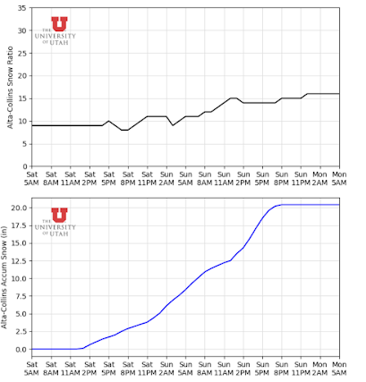
Note - When we as Atmospheric Scientists forecast, we are not so much making predictions that a certain amount of snow will occur but more forecasting the probability that various thresholds will be reached. For example, I forecast 14 - 20 inches for Alta. From a probabilistic standpoint, there is a 75 percent chance Alta exceeds 14 inches and a 25 percent chance Alta exceeds 18 inches. When you see the ensemble plumes (such as the one below), they are not necessarily telling us what will happen but more so showing the range of possible outcomes. For this event, the range of possible outcomes in the Short-Range Ensemble Forecast (SREF) is roughly from 8 inches to 22 inches through 8pm Sunday 1/15 (~16/00Z).

SREF Ensemble Plumes for Accumulated Snow at Alta-Collins, valid 00Z 1/15 through 12Z 1/18. Image courtesy the Department of Atmospheric Sciences, University of Utah.


Long Term Forecast

As we look into the longer term, another weak storm looks to come through late next week after the Tuesday brush-by. We will watch these systems and write more detailed forecasts as they approach. After that, it is looking more likely that we will see a drier pattern set up over Northern Utah through the end of the month. Note that drier is simply relative to our climatological snowfall and recent events and does not necessarily mean dry. It is likely that during this upcoming period, temperatures will be slightly below normal with the chance for occasional precipitation.

ECMWF Weekly 7-day Precipitation Anomaly, valid 00Z January 24 - 00Z January 31. Image courtesy of Weatherbell.


With the last month bringing seemingly endless storms, our mountain employees and snow safety teams have been working around the clock to keep us safe. Be sure to thank a patroller or UDOT employee today!

GEFS 500mb Geopotential Height Anomaly Forecast trend from the past 10 model runs, valid 06Z Saturday, January 28 (11pm MST January 27). Image courtesy of Tropical Tidbits.


Backcountry Comments

Avalanche danger is elevated in the backcountry so be sure to head over to our friends at the Utah Avalanche Center.

Saturday, January 14, 2023

Guess what! More snow on the way!

TL;DR:

The nice weather we've been having over the past few days will break tonight as another storm makes its way into the state. This storm will be smaller than earlier this week, but substantial accumulation is likely in the mountains. The NWS has issued a winter storm warning starting this afternoon and continuing through Sunday evening. 

Nowcast:

We have high clouds over the state currently.

GOES-West image taken at 12:06 MST. Courtesy: College of DuPage ATMOS

Mountain temperatures sit above freezing at the base and below freezing at ridgeline. I expect temperatures to cool off throughout the day. 

Short-term:

A storm will impact the region starting this afternoon/evening and continue through Sunday evening. SREF ensembles show snow accumulation beginning around 6pm MST. The period of highest accumulation will be tomorrow morning around 3am MST. The HRRR shows snow showers stopping around 8pm MST on Sunday. 

As far as accumulation goes, the HRRR LCC guidance shows 20 inches for this storm, and the GFS guidance shows 13 inches. The main difference between the two models is that the GFS has the Wasatch only receiving 1 inch of water, while the HRRR shows 1.75 inches.

HRRR LCC Guidance. Courtesy: UofU ATMOS
Given this discrepancy, the ensemble runs could help. The SREF is made up of two ensemble runs, the ARW and the NBM. All ARW members are sitting around 20 inches, while the NBM members show less than 15 inches. The ARW is based on the WRF model, while the NMB is a suite of many models. There are advantages to each, but this is where the discrepancy between the two outputs come in. See the ensemble output below. 

SREF ensemble output. Courtesy: UofU ATMOS

Given all of this, my accumulation estimate would be a 75% chance of total accumulation >15 inches with a 25% of accumulation of 20 inches at high elevations. 

Long-term:

After the storm this weekend, 2 more storms will impact the state, but they don't look all that promising in the Wasatch. The first storm will come in late next week, but the highest accumulation will be in southern Utah. The second will pass through next weekend and could provide some accumulation in the Wasatch; we'll have more for you next week. 

From a pattern viewpoint, a ridge builds off the West coast after the 2nd storm mentioned above. Right now, it doesn't look too strong, but time will tell. There could be a break to the active pattern we've been in for the past 5 weeks.