TL;DR:
With the end of this epic storm approaching a final push will move through the area tomorrow bringing an additional 3-6". We will have a small break before another possible event in the middle to the end of next week that could bring more snow in time for the holidays.
Nowcast:
If you’re lucky
enough to be in the mountains today I hope you brought your snorkel and your
widest skis, it’s going to be deeeeeeeeep! To accompany the cold smoke snow
that has fallen temperatures are in the low teens around mountain bases and
dipping into the single digits on ridgelines. Snow continues to fall. Westerly winds remain relatively
calm. Down in the valley, we are continuing to see snowfall, if you haven’t
shoveled your sidewalk you might want to before it stacks up too high. If you
will be driving today, drive safe, the roads will continue to be wet and could
be slick.
Last 12hrs:
Alta: Storm Total 50” Last 12hrs 11”
Snowbird: 7”
Brighton: 5”
Solitude: 4”
Park City: 6”
Deer Valley: Storm Total 16”
Snowbasin: Storm Total 25”
Powder Mountain: 4”
Sundance: 1”
 |
| Alta |
Short term:
As the brunt of this storm moves out of the area later this afternoon Mother nature will have one final push. An embedded shortwave trough will deliver the final blow bringing an additional 3-6” throughout the day tomorrow.
 |
| The embedded trough that will impact the area on Thursday. U of U Atmospheric Science |
Temperatures will remain very cold as lots of cold polar air is injected into Utah with the Northerly winds we will experience.
 |
| The advection of cold air from North of Utah is highlighted in blue and the wind is depicted with the purple vectors. Tropical Tidbits |
Long term:
Following this epic storm, we will have some time to dig out and enjoy what has fallen before our next event. As we progress through the end of this week a long ridge will build over the western U.S. but could break at the beginning of next week. The cold polar air will continue to be brought to the area keeping temperatures low. Stay tuned as the storm next week could bring us a white Christmas and Chanukah.
Backcountry comment:
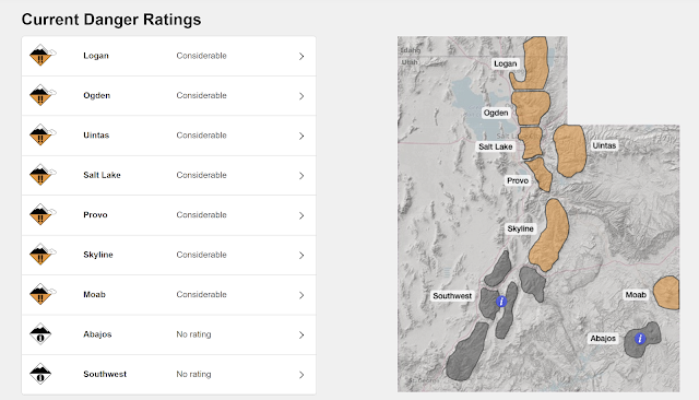
Avalanche conditions are CONSIDERABLE when traveling in the backcountry slopes could be triggered remotely and could slide big. Slides could break as deep as 3' and 200' wide.
If you plan to travel in the backcountry avalanche conditions exist! Ensure you are properly equipped with the right equipment and know before you go. For all things avalanche and a full avalanche forecast check in with our friends over at the Utah Avalanche Center.
 |
| Utah Avalanche Center |
No comments:
Post a Comment