TL;DR: Friday Treat, Early Conditions Present
Nowcast:
11PM Local / 6Z Dec 08: Scattered Clouds to 7,000 ft, 11,000 ft and Broken at 16,000 ft above.
36F at the airport, 65% humidity with a 'gentle breeze' of 7 knots (8 mph) from the SE. 10 mile visibility.
Hills were looking a bit dry and bare from campus this afternoon, let's see what's coming our way:
Short Term:
The NWS Area Forecast Discussion (AFD) issued 3pm Local Dec 7 mentions an incoming cold front that will bring the goods and some precipitation through Friday. The UofU / Mountain Meteorology Campus Weather Station (MTMET) had a temperature drop right at 5pm (Sunset) and a wind shift (purple arrow) from westerly to NE.. the cold front might stand out more as the night develops:
 |
| Colin - Precip Viewer |
This highly experimental, under development, Red Butte Canyon precipitation viewer shows the increased precipitation that had fallen as of 2pm (local) near UofU campus (WBB, 4800ft), and Knowlton's Fork (UATKF, 6600ft).
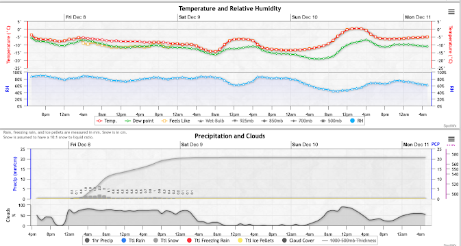
The HRRR (High Resolution Rapid Refresh) model has precipitation starting around 2-3 am with an initial pulse, then a second round early this afternoon:
 |
| spot wx |
Long Term:
A longer range model (RDPS, 3.5 day outlook) has cold-cool conditions continue through the weekend with the bulk of the moisture wrung out by Saturday morning. Fingers crossed for more precipitation monday, come back to the blog and read all about it.
Backcountry Comments:
A buried weak layer of facets makes up the lower basal snowpack. Recent storms and winds have settled on top, and the range experienced an avalanche cycle on this interface. The current snow surface has 'aged' a bit and could be an issue for the new storm snow to bond with.
If you will be traveling in the backcountry make sure you have the proper equipment and know before you go. For the whole avalanche forecast and all things avalanche head over to our friends at the Utah Avalanche Center here: Utah Avalanche Center - Salt Lake


No comments:
Post a Comment