Thursday, February 9, 2023

Sun For Now, Soon We'll Be Ski'n Pow

TL;DR:

    While we sit under high pressure for now, enjoy the sun and get ready for more snow next week!

Nowcast:

    Currently up in the mountains temperatures are low and the sky is clear. Base temps in the cottonwoods are down near zero, even dipping below zero in some areas. Ridgelines are seeing similar temperatures even reaching zero up on Hidden Peak. Winds are moderate in the low twenties coming from the North, Northwest.

Alta


Short term:

    As we move towards the weekend you can expect more of the clear skies and cool temperatures with a ridge of high pressure moving over Utah. There is very little moisture in the area but enough that toward the end of the weekend, we may see some light cloud cover. The trough that is building behind this ridge has an unfavorable fate according to the models as it will spin off into a close low that may move inland too far south of Utah to create any desirable weather.

The area of high pressure can be seen highlighted in purple with Utah residing right in the middle highlighted in green. U of U Atmospheric Science


Long term:

    The weather is looking promising for next week, there is strong potential for another fantastic storm from the Northwest. Following the deceiving low that will likely move to the south of Utah, A strong trough will move in midweek next week with lots of potential for snow. As we have seen lately these storms that come with NW predominant flow have done some overproducing and have made for excellent skiing. Let's keep our fingers crossed. 

The trough that we will see next week coming from the NW. U of U Atmospheric Science


If you plan to travel in the backcountry know before you go and have the proper equipment. Check-in with our friends over at the Utah Avalanche Center for the full avalanche forecast.

Wednesday, February 8, 2023

Windy Days

TLDR; A moisture-starved shortwave trough will pass with favorable dynamics missing just north of northern Utah today leaving the central Wasatch with a chance of 0-2'' of snowfall. A ridge will move overhead after the passing of today's shortwave. 


NOWCAST: Temperatures are currently 15 F at Brighton and 22 F at the base of Alta. Winds at the top of Mt Blady have already reported 37 mph with max gusts of 58 mph. Northwest winds will strengthen and become more Westerly throughout the day.


(Mt Baldy, Alta Mesowest: https://mesowest.utah.edu/)

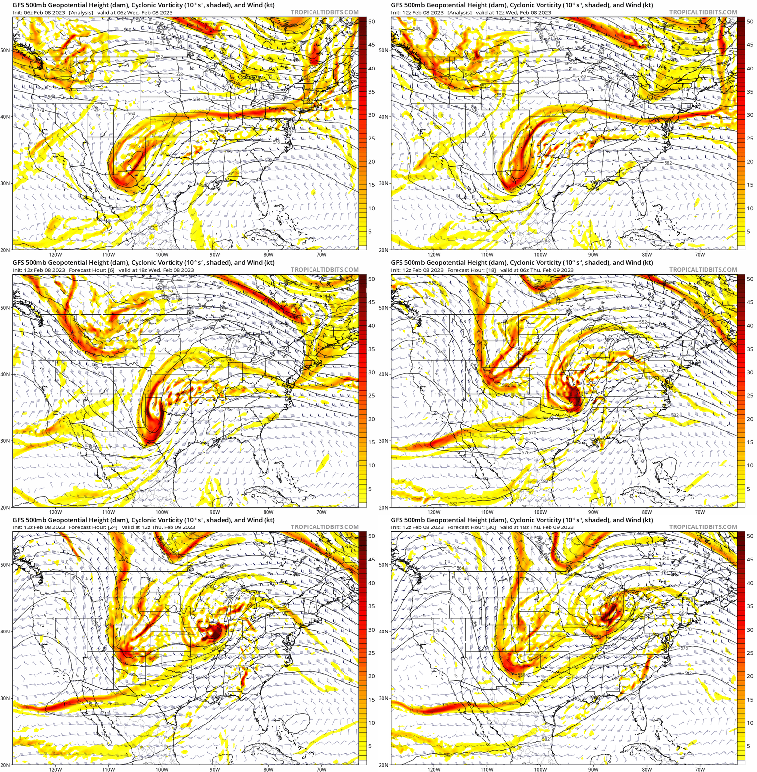
Short-Term Forecast: Daytime high temperatures will be capped today and tomorrow due to a cold front associated with the passing of a shortwave trough. If you plan on being on any ridgelines today, be prepared to find strong winds. Ridgelines at 11,000' could see sustained winds of 40-55 mph with 85 mph wind gusts. Resort skiing will feel "breezy" today with base height winds of 10-20 mph and gusts well over 30 mph. Wind chill values will be hovering around 0 degrees with negative values being a possibility. These winds will strengthen into the night causing wind chill values to drop well below zero. Sadly, this shortwave seems to be moisture starved and its best dynamics are to the north, meaning we are praying for 2" of snow maximum. More likely a trace amount to 1" will fall. The figure below shows 500mb vorticity barely scrapping northern Utah. Ideally, you want to be out ahead of vorticity maximums for the best dynamics and instability.

(500mb Vort and Wind, Tropical Tidbits: https://www.tropicaltidbits.com/)


Long-Term Forecast: A trough will develop into a cutoff low and pass to our south Saturday, pushing out any ridging in the region. This will stop an inversion from building up like this past week. Hints at a storm next Tuesday-Wednesday are in the works but we will need to wait before getting excited. Superbowl Sunday looks like it will be a great day to barbeque! Here's what the upper atmosphere(500mb) will look like 30 minutes after kickoff. Looks dry with calm conditions, partly cloudy skies, and temperatures in the upper 30s. 

(Utah Weather Center: https://weather.utah.edu/)


Tuesday, February 7, 2023

Drying Trend

TL;DR: Yesterday's storm has cleared out, leaving us with dry and cold conditions throughout the Wasatch. A weak wave could bring a dusting of new snow on Wednesday afternoon.

Nowcast: Our last storm brought storm totals ranging from 9-21" in the central Wasatch. Skies are clear this morning and temperatures are in the single digits in spots, with Cardiff Fork in Big Cottonwood Canyon being the low spot at 6 °F as of 8:00 a.m. mountain time. Winds are light out of the north on the mountain ridge lines. Alta's Mount Superior webcam shows a beautiful view of the February sun hitting Mount Superior's south facing slope, as the nearly full moon sets to the west.

Source: Alta Ski Area

Short-Term Forecast: Today will be dry and sunny, before a weak wave impacts the region tomorrow (Wednesday) afternoon. This can be seen in the 0600 UTC GFS, with a tough centered near the Wyoming/Idaho/Montana border tomorrow around mid-day (left panel). The right panel shows that precipitation rates will be light, with the best chances for precipitation in northern Utah. I'd expect maybe an inch or two of snow tomorrow afternoon for the central Wasatch.
Source: University of Utah Department of Atmospheric Science

Cold air will follow this wave, before we warm up for the weekend.

Mid-Long-Range Forecast: The weekend looks dry and warmer, with a ridge building over the interior western United States. This will keep most precipitation along the Pacific Coast. The next chances for precipitation look to be around mid month.

Wrap-Up: Enjoy today's sunshine! Expect maybe an inch or two of snow tomorrow before we dry out for the weekend.


Monday, February 6, 2023

Death and Rebirth

 TL;DR:

The return of snow to the Central Wasatch has greatly refreshed skiing conditions and brought with it the death of the persistent pollution that has been lingering in Northern Utah.


Current Conditions

Temperatures are ranging from the lower 20s on the Wasatch Back at Park City Mountain Resort to mid-teens for the mid-elevations of the Cottonwoods to 8F at Mount Baldy at 11,000'. Light winds and snowfall continue this morning. Road conditions are treacherous as UDOT reports numerous vehicles with 4FD/AWD and snow tires having difficulty in the Cottonwoods this morning. Drive safe!

Low-visibility and snow! Image courtesy of Alta Ski Area.

Short Term Forecast

Snow showers will continue through today, tapering off by the evening hours. Temperatures will remain relatively cool today with overcast skies before clearer skies and warmer temperatures return tomorrow. After this storm wraps up, dry and warm weather will return as brief positively tilted ridge sets up over the Southwestern United States. The image below shows the positive tilt of the ridge axis denoted by the red line on the 500mb Geopotential Height plot.


GFS 500mb Geopotential Height valid 5am MST Tuesday, February 7. Image courtesy of the University of Utah, Department of Atmospheric Sciences. 


Long Term Forecast

The potential for another storm later in the work week remains. However, I am interested in its potential to mix out pollution in the Salt Lake Valley more so than any notable snow totals. Better chances for substantial snowfall look to return to the area sometime next weekend if the current models hold that pattern. Looking at the plot below, minimal snow accumulations can be expected through mid week.

Short-Range Ensemble Forecast (SREF) Downscaled ensemble mean snow and probability of >1" snow valid 0200 MST February 6 through 1700 MST February 9. Image courtesy of the University of Utah, Department of Atmospheric Sciences. 

Wednesday, February 1, 2023

Bluebird Trend

TL;DR:

A high pressure system will keep us dry for the next few days, and as the ridge moves out of the area it will allow weak storm energy to enter the region this weekend with the possibility for light accumulation. For now enjoy the bluebird skiing while it lasts.

Photo Courtesy of Alta.com

Nowcast:
It is currently 10 degrees F at the base of Alta right now with a high of 20 F today. There are few high atmospheric clouds which means the sun will be strong and present most of the day making it feel warmer. Light winds form the Northwest are blowing at less than 10 mph in the valleys, and 20 mph on the ridges and peaks with gusts up to 30 mph. After a few really cold days it's nice to see the temperatures rise.

Short Term:
High pressure is west of Utah, but making its way towards us which will allow temperatures to warm in the next couple of days. Along with rising temperatures and stable conditions we will see inversions in the valley get worse over the next couple of days as well. With temperatures still well below freezing the aspects that receive the least amount of sun should retain soft powder conditions.
GFS 500 mb geopotential height anomaly, (tropicaltidbits.com)

Long Term:
Pictured above is the low pressure system that begins to enter the region on Friday and will lasts into Tuesday. Beginning on Friday we will see cloudy skies with a low chance of snow, and if any it will be the mountains that will receive a dusting. Sunday night through Tuesday has more likelihood for decent accumulation, but the amount is unknown right now as there isn't much agreeance between models. Enjoy the sun on your skin for the next few days, and pray for this system to have more favorable outcomes than we are seeing right now!

Backcountry comments:


If you will be traveling in the backcountry make sure you have the proper equipment and know before you go. For the whole avalanche forecast and all things avalanche head over to our friends at the Utah Avalanche Center. (https://utahavalanchecenter.org/)